Jugeals-Nazareth geodata
Jugeals-Nazareth (Nouvelle-Aquitaine) is a populated place; located in France in Europe/Paris (GMT+2) time zone. With population of 702 people, there are 11777 cities with bigger population in this country. Compared to other cities in France, 78.8% of cities are located further ↑North; 62.2% of cities are located further →East and 83.8% of cities have lower elevation than Jugeals-Nazareth. Note1
Administrative division(s):
- Level 1: Nouvelle-Aquitaine
- Level 2: Département de la Corrèze
- Level 3: Arrondissement de Brive-la-Gaillarde
- Level 4: Jugeals-Nazareth


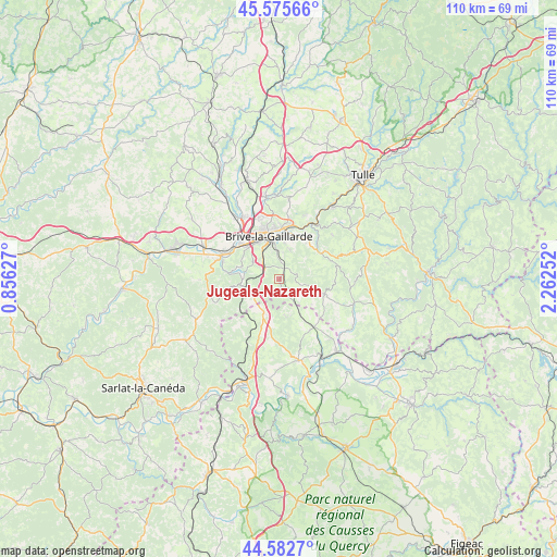
Jugeals-Nazareth GPS coordinates[2]
45° 4' 52.824" North, 1° 33' 33.804" East
| Map corner | latitude | longitude |
|---|---|---|
| Upper-left | 45.57566°, | 0.85627° |
| Center: | 45.08134°, | 1.55939° |
| Lower-right: | 44.5827°, | 2.26252° |
| Map W x H: | 110.4×110.4 km | = 68.6×68.6mi |
| max Lat: | 51.07786° ⇑78.8% North |
| Jugeals-Nazareth: | 45.08134° |
| min Lat: | ⇓21.2% South 41.3874° |
| min Long | Jugeals-Nazaret | max Long |
| -5.08615° | 1.55939° | 9.52242° |
| W 37.8%⇐ | ⇒62.2% E |
Elevation
Elevation of Jugeals-Nazareth is 332 m = 1089 ft, and this is 138.3 m = 454 ft above average elevation for this country.
| Max E: |
2333 m = 7654 ft | 16.2% |
| Jugeals-Nazareth | 332 m 1089 ft | |
| Avg. | 193.7 m = 635 ft | |
Min E: |
-1 m = -3 ft | 83.8% |
See also: France elevation on elevation.city.
Geographical zone
Jugeals-Nazareth is located in North temperate zone (between Tropic of Cancer and the Arctic Circle). Distance of this North polar circle is 2388.6 km =1484.2 mi to North.| Distance of | km | miles | from Jugeals-Nazareth |
|---|---|---|---|
| North Pole | 4994.5 | 3103.4 | to North |
| Arctic Circle | 2388.6 | 1484.2 | to North |
| Tropic Cancer | 2406.7 | 1495.5 | to South |
| Equator | 5012.6 | 3114.7 | to South |


Nearby cities:
15 places around Jugeals-Nazareth: (largest is in red/bold)
• Brive-la-Gaillarde
8.9 km =5.5 mi,  346°
346°
• Chasteaux
7.3 km =4.5 mi,  280°
280°
• Cosnac
6.2 km =3.9 mi,  19°
19°
• Cressensac
7.2 km =4.5 mi,  204°
204°
• Dampniat
11.2 km =7 mi,  30°
30°
• Gignac
11.6 km =7.2 mi,  223°
223°
• Les Quatre-Routes-du-Lot
11.5 km =7.1 mi,  141°
141°
• Lissac-sur-Couze
8.1 km =5 mi,  288°
288°
• Malemort-sur-Corrèze
9.9 km =6.2 mi,  2°
2°
• Meyssac
9.5 km =5.9 mi,  107°
107°
• Nespouls
5.7 km =3.5 mi,  231°
231°
• Noailles
3.7 km =2.3 mi,  309°
309°
• Saint-Pantaléon-de-Larche
11.1 km =6.9 mi, 306°
• Sarrazac
7.5 km =4.7 mi,  161°
161°
• Turenne
3.5 km =2.2 mi,  149°
149°
Sources, notices
• [Note1] Compared only with cities in France existing in our database
• [Src1] Map data: © OpenStreetMap contributors (CC-BY-SA)
• [Src2] Other city data from geonames.org with taken over terms of usage.
• [Src3] Geographical zone / Annual Mean Temperature by Robert A. Rohde @ Wikipedia
