Lissac-sur-Couze geodata
Lissac-sur-Couze (Nouvelle-Aquitaine) is a populated place; located in France in Europe/Paris (GMT+2) time zone. With population of 538 people, there are 14429 cities with bigger population in this country. Compared to other cities in France, 78.5% of cities are located further ↑North; 63.5% of cities are located further →East and 70.9% of cities have lower elevation than Lissac-sur-Couze. Note1
Administrative division(s):
- Level 1: Nouvelle-Aquitaine
- Level 2: Département de la Corrèze
- Level 3: Arrondissement de Brive-la-Gaillarde
- Level 4: Lissac-sur-Couze


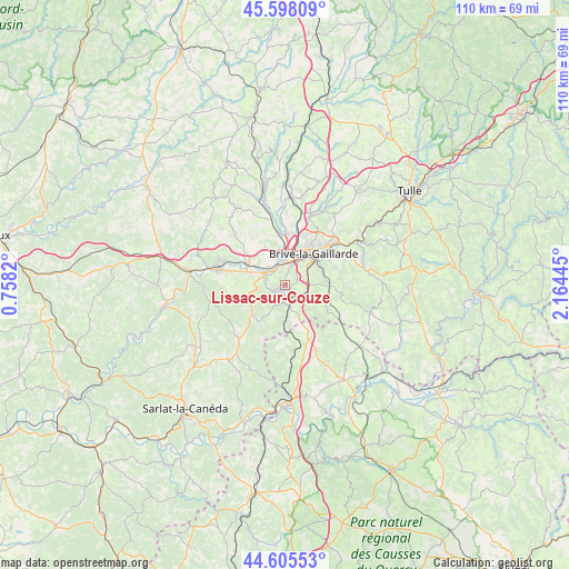
Lissac-sur-Couze GPS coordinates[2]
45° 6' 14.292" North, 1° 27' 40.788" East
| Map corner | latitude | longitude |
|---|---|---|
| Upper-left | 45.59809°, | 0.7582° |
| Center: | 45.10397°, | 1.46133° |
| Lower-right: | 44.60553°, | 2.16445° |
| Map W x H: | 110.4×110.4 km | = 68.6×68.6mi |
| max Lat: | 51.07786° ⇑78.5% North |
| Lissac-sur-Couze: | 45.10397° |
| min Lat: | ⇓21.5% South 41.3874° |
| min Long | Lissac-sur-Couz | max Long |
| -5.08615° | 1.46133° | 9.52242° |
| W 36.5%⇐ | ⇒63.5% E |
Elevation
Elevation of Lissac-sur-Couze is 223 m = 732 ft, and this is 29.3 m = 96 ft above average elevation for this country.
| Max E: |
2333 m = 7654 ft | 29.1% |
| Lissac-sur-Couze | 223 m 732 ft | |
| Avg. | 193.7 m = 635 ft | |
Min E: |
-1 m = -3 ft | 70.9% |
See also: France elevation on elevation.city.
Geographical zone
Lissac-sur-Couze is located in North temperate zone (between Tropic of Cancer and the Arctic Circle). Distance of this North polar circle is 2386.1 km =1482.7 mi to North.| Distance of | km | miles | from Lissac-sur-Couze |
|---|---|---|---|
| North Pole | 4992 | 3101.9 | to North |
| Arctic Circle | 2386.1 | 1482.7 | to North |
| Tropic Cancer | 2409.2 | 1497 | to South |
| Equator | 5015.1 | 3116.2 | to South |


Nearby cities:
15 places around Lissac-sur-Couze: (largest is in red/bold)
• Brive-la-Gaillarde
8.3 km =5.2 mi,  42°
42°
• Chasteaux
1.3 km =0.8 mi,  157°
157°
• Cosnac
10.3 km =6.4 mi,  70°
70°
• Cressensac
10.2 km =6.3 mi,  152°
152°
• Jugeals-Nazareth
8.1 km =5 mi,  108°
108°
• Larche
4 km =2.5 mi,  297°
297°
• Malemort-sur-Corrèze
10.9 km =6.8 mi,  47°
47°
• Mansac
9.4 km =5.8 mi,  319°
319°
• Nespouls
6.8 km =4.2 mi, 151°
• Noailles
4.8 km =3 mi,  91°
91°
• Pazayac
6.7 km =4.2 mi,  287°
287°
• Saint-Pantaléon-de-Larche
4.3 km =2.7 mi,  344°
344°
• Turenne
11 km =6.8 mi,  120°
120°
• Ussac
10.8 km =6.7 mi,  22°
22°
• Varetz
10 km =6.2 mi,  355°
355°
Sources, notices
• [Note1] Compared only with cities in France existing in our database
• [Src1] Map data: © OpenStreetMap contributors (CC-BY-SA)
• [Src2] Other city data from geonames.org with taken over terms of usage.
• [Src3] Geographical zone / Annual Mean Temperature by Robert A. Rohde @ Wikipedia
