Turenne geodata
Turenne (Nouvelle-Aquitaine) is a populated place; located in France in Europe/Paris (GMT+2) time zone. With population of 776 people, there are 10868 cities with bigger population in this country. Compared to other cities in France, 79% of cities are located further ↑North; 62% of cities are located further →East and 78.1% of cities have lower elevation than Turenne. Note1
Administrative division(s):
- Level 1: Nouvelle-Aquitaine
- Level 2: Département de la Corrèze
- Level 3: Arrondissement de Brive-la-Gaillarde
- Level 4: Turenne


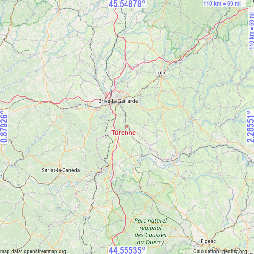
Turenne GPS coordinates[2]
45° 3' 15.192" North, 1° 34' 56.568" East
| Map corner | latitude | longitude |
|---|---|---|
| Upper-left | 45.54878°, | 0.87926° |
| Center: | 45.05422°, | 1.58238° |
| Lower-right: | 44.55535°, | 2.28551° |
| Map W x H: | 110.5×110.5 km | = 68.7×68.7mi |
| max Lat: | 51.07786° ⇑79% North |
| Turenne: | 45.05422° |
| min Lat: | ⇓21% South 41.3874° |
| min Long | Turenne | max Long |
| -5.08615° | 1.58238° | 9.52242° |
| W 38%⇐ | ⇒62% E |
Elevation
Elevation of Turenne is 273 m = 896 ft, and this is 79.3 m = 260 ft above average elevation for this country.
| Max E: |
2333 m = 7654 ft | 21.9% |
| Turenne | 273 m 896 ft | |
| Avg. | 193.7 m = 635 ft | |
Min E: |
-1 m = -3 ft | 78.1% |
See also: France elevation on elevation.city.
Geographical zone
Turenne is located in North temperate zone (between Tropic of Cancer and the Arctic Circle). Distance of this North polar circle is 2391.6 km =1486.1 mi to North.| Distance of | km | miles | from Turenne |
|---|---|---|---|
| North Pole | 4997.5 | 3105.3 | to North |
| Arctic Circle | 2391.6 | 1486.1 | to North |
| Tropic Cancer | 2403.6 | 1493.5 | to South |
| Equator | 5009.6 | 3112.8 | to South |


Nearby cities:
15 places around Turenne: (largest is in red/bold)
• Brive-la-Gaillarde
12.3 km =7.6 mi,  341°
341°
• Chasteaux
10 km =6.2 mi,  295°
295°
• Cosnac
8.9 km =5.5 mi,  1°
1°
• Cressensac
6 km =3.7 mi,  233°
233°
• Dampniat
13.2 km =8.2 mi,  17°
17°
• Gignac
11.2 km =7 mi,  241°
241°
• Jugeals-Nazareth
3.5 km =2.2 mi,  329°
329°
• Les Quatre-Routes-du-Lot
8 km =5 mi,  138°
138°
• Lissac-sur-Couze
11 km =6.8 mi, 300°
• Malemort-sur-Corrèze
13 km =8.1 mi,  353°
353°
• Martel
13.2 km =8.2 mi,  171°
171°
• Meyssac
7.2 km =4.5 mi,  88°
88°
• Nespouls
6.3 km =3.9 mi,  265°
265°
• Noailles
7.2 km =4.5 mi,  319°
319°
• Sarrazac
4.2 km =2.6 mi, 172°
Sources, notices
• [Note1] Compared only with cities in France existing in our database
• [Src1] Map data: © OpenStreetMap contributors (CC-BY-SA)
• [Src2] Other city data from geonames.org with taken over terms of usage.
• [Src3] Geographical zone / Annual Mean Temperature by Robert A. Rohde @ Wikipedia
