Geispolsheim geodata
Geispolsheim (Grand Est) is a populated place; located in France in Europe/Paris (GMT+2) time zone. With population of 7,410 people, there are 1318 cities with bigger population in this country. Compared to other cities in France, 68.7% of cities are located further ↓South; 98.8% of cities are located further ←West and 53.9% of cities have lower elevation than Geispolsheim. Note1
Administrative division(s):
- Level 1: Grand Est
- Level 2: Bas-Rhin
- Level 3: Arrondissement de Strasbourg
- Level 4: Geispolsheim


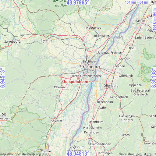
Geispolsheim GPS coordinates[2]
48° 30' 57.708" North, 7° 38' 53.7" East
| Map corner | latitude | longitude |
|---|---|---|
| Upper-left | 48.97965°, | 6.94513° |
| Center: | 48.51603°, | 7.64825° |
| Lower-right: | 48.04813°, | 8.35138° |
| Map W x H: | 103.6×103.6 km | = 64.4×64.4mi |
| max Lat: | 51.07786° ⇑31.3% North |
| Geispolsheim: | 48.51603° |
| min Lat: | ⇓68.7% South 41.3874° |
| min Long | Geispolsheim | max Long |
| -5.08615° | 7.64825° | 9.52242° |
| W 98.8%⇐ | ⇒1.2% E |
Elevation
Elevation of Geispolsheim is 146 m = 479 ft, and this is 47.7 m = 156 ft below average elevation for this country.
| Max E: |
2333 m = 7654 ft | 46.1% |
| Avg. | 193.7 m = 635 ft | |
| Geispolsheim | 146 m = 479 ft | |
Min E: |
-1 m = -3 ft | 53.9% |
See also: France elevation on elevation.city.
Geographical zone
Geispolsheim is located in North temperate zone (between Tropic of Cancer and the Arctic Circle). Distance of this North polar circle is 2006.7 km =1246.9 mi to North.| Distance of | km | miles | from Geispolsheim |
|---|---|---|---|
| North Pole | 4612.6 | 2866.1 | to North |
| Arctic Circle | 2006.7 | 1246.9 | to North |
| Tropic Cancer | 2788.6 | 1732.8 | to South |
| Equator | 5394.5 | 3352 | to South |


Nearby cities:
15 places around Geispolsheim: (largest is in red/bold)
• Blaesheim
3.1 km =1.9 mi,  249°
249°
• Duppigheim
4.2 km =2.6 mi,  289°
289°
• Duttlenheim
6.2 km =3.9 mi,  279°
279°
• Entzheim
2.2 km =1.4 mi,  339°
339°
• Eschau
5.9 km =3.7 mi,  120°
120°
• Fegersheim
3.8 km =2.4 mi,  139°
139°
• Hangenbieten
5.5 km =3.4 mi,  333°
333°
• Hindisheim
5.3 km =3.3 mi,  187°
187°
• Hipsheim
5.8 km =3.6 mi,  159°
159°
• Holtzheim
4.7 km =2.9 mi,  356°
356°
• Illkirch-Graffenstaden
5.1 km =3.2 mi,  73°
73°
• Innenheim
5.9 km =3.7 mi, 248°
• Lingolsheim
5.3 km =3.3 mi,  28°
28°
• Lipsheim
3.1 km =1.9 mi,  152°
152°
• Ostwald
5.5 km =3.4 mi,  56°
56°
Sources, notices
• [Note1] Compared only with cities in France existing in our database
• [Src1] Map data: © OpenStreetMap contributors (CC-BY-SA)
• [Src2] Other city data from geonames.org with taken over terms of usage.
• [Src3] Geographical zone / Annual Mean Temperature by Robert A. Rohde @ Wikipedia
