Blaesheim geodata
Blaesheim (Grand Est) is a populated place; located in France in Europe/Paris (GMT+2) time zone. With population of 1,443 people, there are 6415 cities with bigger population in this country. Compared to other cities in France, 68.4% of cities are located further ↓South; 98.6% of cities are located further ←West and 55.9% of cities have lower elevation than Blaesheim. Note1
Administrative division(s):
- Level 1: Grand Est
- Level 2: Bas-Rhin
- Level 3: Arrondissement de Strasbourg
- Level 4: Blaesheim


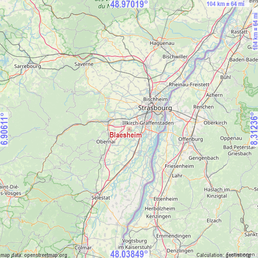
Blaesheim GPS coordinates[2]
48° 30' 23.328" North, 7° 36' 33.228" East
| Map corner | latitude | longitude |
|---|---|---|
| Upper-left | 48.97019°, | 6.90611° |
| Center: | 48.50648°, | 7.60923° |
| Lower-right: | 48.03849°, | 8.31236° |
| Map W x H: | 103.6×103.6 km | = 64.4×64.4mi |
| max Lat: | 51.07786° ⇑31.6% North |
| Blaesheim: | 48.50648° |
| min Lat: | ⇓68.4% South 41.3874° |
| min Long | Blaesheim | max Long |
| -5.08615° | 7.60923° | 9.52242° |
| W 98.6%⇐ | ⇒1.4% E |
Elevation
Elevation of Blaesheim is 153 m = 502 ft, and this is 40.7 m = 134 ft below average elevation for this country.
| Max E: |
2333 m = 7654 ft | 44.1% |
| Avg. | 193.7 m = 635 ft | |
| Blaesheim | 153 m = 502 ft | |
Min E: |
-1 m = -3 ft | 55.9% |
See also: France elevation on elevation.city.
Geographical zone
Blaesheim is located in North temperate zone (between Tropic of Cancer and the Arctic Circle). Distance of this North polar circle is 2007.8 km =1247.6 mi to North.| Distance of | km | miles | from Blaesheim |
|---|---|---|---|
| North Pole | 4613.6 | 2866.8 | to North |
| Arctic Circle | 2007.8 | 1247.6 | to North |
| Tropic Cancer | 2787.5 | 1732.1 | to South |
| Equator | 5393.4 | 3351.3 | to South |


Nearby cities:
15 places around Blaesheim: (largest is in red/bold)
• Altorf
6.2 km =3.9 mi,  285°
285°
• Duppigheim
2.7 km =1.7 mi,  335°
335°
• Duttlenheim
3.8 km =2.4 mi,  303°
303°
• Entzheim
3.7 km =2.3 mi,  34°
34°
• Fegersheim
5.6 km =3.5 mi,  108°
108°
• Geispolsheim
3.1 km =1.9 mi,  69°
69°
• Griesheim-près-Molsheim
5.8 km =3.6 mi,  266°
266°
• Hangenbieten
5.9 km =3.7 mi,  3°
3°
• Hindisheim
4.8 km =3 mi,  152°
152°
• Holtzheim
6.3 km =3.9 mi,  24°
24°
• Innenheim
2.8 km =1.7 mi,  246°
246°
• Kolbsheim
6.2 km =3.9 mi,  346°
346°
• Krautergersheim
4.6 km =2.9 mi,  222°
222°
• Limersheim
6.3 km =3.9 mi,  155°
155°
• Lipsheim
4.6 km =2.9 mi, 111°
Sources, notices
• [Note1] Compared only with cities in France existing in our database
• [Src1] Map data: © OpenStreetMap contributors (CC-BY-SA)
• [Src2] Other city data from geonames.org with taken over terms of usage.
• [Src3] Geographical zone / Annual Mean Temperature by Robert A. Rohde @ Wikipedia
