Fegersheim geodata
Fegersheim (Grand Est) is a populated place; located in France in Europe/Paris (GMT+2) time zone. With population of 4,919 people, there are 2012 cities with bigger population in this country. Compared to other cities in France, 68.1% of cities are located further ↓South; 98.9% of cities are located further ←West and 54.5% of cities have lower elevation than Fegersheim. Note1
Administrative division(s):
- Level 1: Grand Est
- Level 2: Bas-Rhin
- Level 3: Arrondissement de Strasbourg
- Level 4: Fegersheim


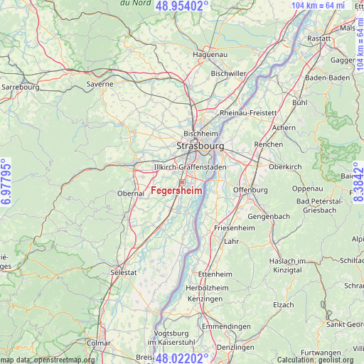
Fegersheim GPS coordinates[2]
48° 29' 24.576" North, 7° 40' 51.852" East
| Map corner | latitude | longitude |
|---|---|---|
| Upper-left | 48.95402°, | 6.97795° |
| Center: | 48.49016°, | 7.68107° |
| Lower-right: | 48.02202°, | 8.3842° |
| Map W x H: | 103.6×103.6 km | = 64.4×64.4mi |
| max Lat: | 51.07786° ⇑31.9% North |
| Fegersheim: | 48.49016° |
| min Lat: | ⇓68.1% South 41.3874° |
| min Long | Fegersheim | max Long |
| -5.08615° | 7.68107° | 9.52242° |
| W 98.9%⇐ | ⇒1.1% E |
Elevation
Elevation of Fegersheim is 148 m = 486 ft, and this is 45.7 m = 150 ft below average elevation for this country.
| Max E: |
2333 m = 7654 ft | 45.5% |
| Avg. | 193.7 m = 635 ft | |
| Fegersheim | 148 m = 486 ft | |
Min E: |
-1 m = -3 ft | 54.5% |
See also: France elevation on elevation.city.
Geographical zone
Fegersheim is located in North temperate zone (between Tropic of Cancer and the Arctic Circle). Distance of this North polar circle is 2009.6 km =1248.7 mi to North.| Distance of | km | miles | from Fegersheim |
|---|---|---|---|
| North Pole | 4615.5 | 2867.9 | to North |
| Arctic Circle | 2009.6 | 1248.7 | to North |
| Tropic Cancer | 2785.7 | 1731 | to South |
| Equator | 5391.6 | 3350.2 | to South |


Nearby cities:
15 places around Fegersheim: (largest is in red/bold)
• Blaesheim
5.6 km =3.5 mi,  288°
288°
• Duppigheim
7.7 km =4.8 mi,  303°
303°
• Entzheim
5.8 km =3.6 mi,  326°
326°
• Erstein
7.5 km =4.7 mi,  190°
190°
• Eschau
2.6 km =1.6 mi,  92°
92°
• Geispolsheim
3.8 km =2.4 mi,  319°
319°
• Hindisheim
4 km =2.5 mi,  232°
232°
• Hipsheim
2.6 km =1.6 mi, 187°
• Illkirch-Graffenstaden
5 km =3.1 mi,  30°
30°
• Limersheim
4.7 km =2.9 mi,  214°
214°
• Lingolsheim
7.5 km =4.7 mi,  0°
0°
• Lipsheim
1 km =0.6 mi,  279°
279°
• Nordhouse
4.7 km =2.9 mi, 187°
• Ostwald
6.3 km =3.9 mi,  20°
20°
• Plobsheim
3.9 km =2.4 mi,  125°
125°
Sources, notices
• [Note1] Compared only with cities in France existing in our database
• [Src1] Map data: © OpenStreetMap contributors (CC-BY-SA)
• [Src2] Other city data from geonames.org with taken over terms of usage.
• [Src3] Geographical zone / Annual Mean Temperature by Robert A. Rohde @ Wikipedia
