Gandelu geodata
Gandelu (Hauts-de-France) is a populated place; located in France in Europe/Paris (GMT+2) time zone. With population of 648 people, there are 12550 cities with bigger population in this country. Compared to other cities in France, 82% of cities are located further ↓South; 60.4% of cities are located further ←West and 66.6% of cities have higher elevation than Gandelu. Note1
Administrative division(s):
- Level 1: Hauts-de-France
- Level 2: Département de l'Aisne
- Level 3: Arrondissement de Château-Thierry
- Level 4: Gandelu


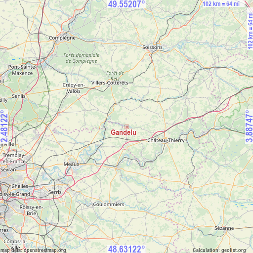
Gandelu GPS coordinates[2]
49° 5' 37.608" North, 3° 11' 3.66" East
| Map corner | latitude | longitude |
|---|---|---|
| Upper-left | 49.55207°, | 2.48122° |
| Center: | 49.09378°, | 3.18435° |
| Lower-right: | 48.63122°, | 3.88747° |
| Map W x H: | 102.4×102.4 km | = 63.6×63.6mi |
| max Lat: | 51.07786° ⇑18% North |
| Gandelu: | 49.09378° |
| min Lat: | ⇓82% South 41.3874° |
| min Long | Gandelu | max Long |
| -5.08615° | 3.18435° | 9.52242° |
| W 60.4%⇐ | ⇒39.6% E |
Elevation
Elevation of Gandelu is 86 m = 282 ft, and this is 107.7 m = 353 ft below average elevation for this country.
| Max E: |
2333 m = 7654 ft | 66.6% |
| Avg. | 193.7 m = 635 ft | |
| Gandelu | 86 m = 282 ft | |
Min E: |
-1 m = -3 ft | 33.4% |
See also: France elevation on elevation.city.
Geographical zone
Gandelu is located in North temperate zone (between Tropic of Cancer and the Arctic Circle). Distance of this North polar circle is 1942.5 km =1207 mi to North.| Distance of | km | miles | from Gandelu |
|---|---|---|---|
| North Pole | 4548.3 | 2826.2 | to North |
| Arctic Circle | 1942.5 | 1207 | to North |
| Tropic Cancer | 2852.8 | 1772.6 | to South |
| Equator | 5458.7 | 3391.9 | to South |


Nearby cities:
15 places around Gandelu: (largest is in red/bold)
• Cocherel
10 km =6.2 mi,  216°
216°
• Coulombs-en-Valois
4.8 km =3 mi,  230°
230°
• Crouy-sur-Ourcq
8 km =5 mi,  266°
266°
• Domptin
11 km =6.8 mi,  141°
141°
• La Ferté-Milon
9.8 km =6.1 mi,  335°
335°
• Mareuil-sur-Ourcq
9.1 km =5.7 mi,  302°
302°
• Marolles
10.3 km =6.4 mi,  325°
325°
• May-en-Multien
12 km =7.5 mi,  258°
258°
• Montreuil-aux-Lions
8.1 km =5 mi,  174°
174°
• Nanteuil-sur-Marne
13.1 km =8.1 mi, 168°
• Neuilly-Saint-Front
10.3 km =6.4 mi,  34°
34°
• Rouvres-en-Multien
11.3 km =7 mi,  283°
283°
• Sainte-Aulde
11.2 km =7 mi,  184°
184°
• Vendrest
8.4 km =5.2 mi, 231°
• Épaux-Bézu
12 km =7.5 mi,  82°
82°
Sources, notices
• [Note1] Compared only with cities in France existing in our database
• [Src1] Map data: © OpenStreetMap contributors (CC-BY-SA)
• [Src2] Other city data from geonames.org with taken over terms of usage.
• [Src3] Geographical zone / Annual Mean Temperature by Robert A. Rohde @ Wikipedia
