Marolles geodata
Marolles (Hauts-de-France) is a populated place; located in France in Europe/Paris (GMT+2) time zone. With population of 654 people, there are 12467 cities with bigger population in this country. Compared to other cities in France, 83.7% of cities are located further ↓South; 59.4% of cities are located further ←West and 69.2% of cities have higher elevation than Marolles. Note1
Administrative division(s):
- Level 1: Hauts-de-France
- Level 2: Département de l'Oise
- Level 3: Arrondissement de Senlis
- Level 4: Marolles


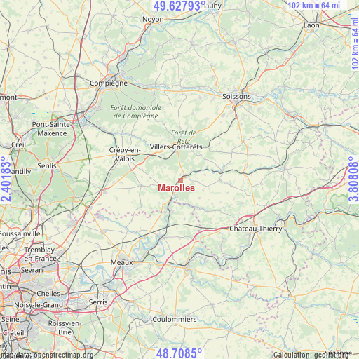
Marolles GPS coordinates[2]
49° 10' 13.26" North, 3° 6' 17.82" East
| Map corner | latitude | longitude |
|---|---|---|
| Upper-left | 49.62793°, | 2.40183° |
| Center: | 49.17035°, | 3.10495° |
| Lower-right: | 48.7085°, | 3.80808° |
| Map W x H: | 102.2×102.2 km | = 63.5×63.5mi |
| max Lat: | 51.07786° ⇑16.3% North |
| Marolles: | 49.17035° |
| min Lat: | ⇓83.7% South 41.3874° |
| min Long | Marolles | max Long |
| -5.08615° | 3.10495° | 9.52242° |
| W 59.4%⇐ | ⇒40.6% E |
Elevation
Elevation of Marolles is 80 m = 262 ft, and this is 113.7 m = 373 ft below average elevation for this country.
| Max E: |
2333 m = 7654 ft | 69.2% |
| Avg. | 193.7 m = 635 ft | |
| Marolles | 80 m = 262 ft | |
Min E: |
-1 m = -3 ft | 30.8% |
See also: France elevation on elevation.city.
Geographical zone
Marolles is located in North temperate zone (between Tropic of Cancer and the Arctic Circle). Distance of this North polar circle is 1933.9 km =1201.7 mi to North.| Distance of | km | miles | from Marolles |
|---|---|---|---|
| North Pole | 4539.8 | 2820.9 | to North |
| Arctic Circle | 1933.9 | 1201.7 | to North |
| Tropic Cancer | 2861.3 | 1777.9 | to South |
| Equator | 5467.2 | 3397.2 | to South |


Nearby cities:
15 places around Marolles: (largest is in red/bold)
• Acy-en-Multien
13.1 km =8.1 mi,  235°
235°
• Betz
11 km =6.8 mi,  261°
261°
• Coulombs-en-Valois
11.7 km =7.3 mi,  169°
169°
• Crouy-sur-Ourcq
9.2 km =5.7 mi,  193°
193°
• Gandelu
10.3 km =6.4 mi,  145°
145°
• Haramont
12.4 km =7.7 mi,  345°
345°
• La Ferté-Milon
1.8 km =1.1 mi,  75°
75°
• Mareuil-sur-Ourcq
4.1 km =2.5 mi,  208°
208°
• May-en-Multien
12.4 km =7.7 mi, 208°
• Neuilly-Saint-Front
11.6 km =7.2 mi,  90°
90°
• Rouvres-en-Multien
7.9 km =4.9 mi,  221°
221°
• Vauciennes
9.1 km =5.7 mi,  323°
323°
• Vaumoise
11.6 km =7.2 mi,  308°
308°
• Vendrest
13.8 km =8.6 mi,  183°
183°
• Villers-Cotterêts
9.3 km =5.8 mi, 353°
Sources, notices
• [Note1] Compared only with cities in France existing in our database
• [Src1] Map data: © OpenStreetMap contributors (CC-BY-SA)
• [Src2] Other city data from geonames.org with taken over terms of usage.
• [Src3] Geographical zone / Annual Mean Temperature by Robert A. Rohde @ Wikipedia
