Épaux-Bézu geodata
Épaux-Bézu (Hauts-de-France) is a populated place; located in France in Europe/Paris (GMT+2) time zone. With population of 542 people, there are 14349 cities with bigger population in this country. Compared to other cities in France, 82.4% of cities are located further ↓South; 62.6% of cities are located further ←West and 51.7% of cities have higher elevation than Épaux-Bézu. Note1
Administrative division(s):
- Level 1: Hauts-de-France
- Level 2: Département de l'Aisne
- Level 3: Arrondissement de Château-Thierry
- Level 4: Épaux-Bézu


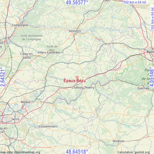
Épaux-Bézu GPS coordinates[2]
49° 6' 27.396" North, 3° 20' 53.988" East
| Map corner | latitude | longitude |
|---|---|---|
| Upper-left | 49.56577°, | 2.64521° |
| Center: | 49.10761°, | 3.34833° |
| Lower-right: | 48.64518°, | 4.05146° |
| Map W x H: | 102.4×102.4 km | = 63.6×63.6mi |
| max Lat: | 51.07786° ⇑17.6% North |
| Épaux-Bézu: | 49.10761° |
| min Lat: | ⇓82.4% South 41.3874° |
| min Long | Épaux-Bézu | max Long |
| -5.08615° | 3.34833° | 9.52242° |
| W 62.6%⇐ | ⇒37.4% E |
Elevation
Elevation of Épaux-Bézu is 126 m = 413 ft, and this is 67.7 m = 222 ft below average elevation for this country.
| Max E: |
2333 m = 7654 ft | 51.7% |
| Avg. | 193.7 m = 635 ft | |
| Épaux-Bézu | 126 m = 413 ft | |
Min E: |
-1 m = -3 ft | 48.3% |
See also: France elevation on elevation.city.
Geographical zone
Épaux-Bézu is located in North temperate zone (between Tropic of Cancer and the Arctic Circle). Distance of this North polar circle is 1940.9 km =1206 mi to North.| Distance of | km | miles | from Épaux-Bézu |
|---|---|---|---|
| North Pole | 4546.8 | 2825.2 | to North |
| Arctic Circle | 1940.9 | 1206 | to North |
| Tropic Cancer | 2854.3 | 1773.6 | to South |
| Equator | 5460.3 | 3392.9 | to South |


Nearby cities:
15 places around Épaux-Bézu: (largest is in red/bold)
• Beuvardes
10.9 km =6.8 mi,  69°
69°
• Brasles
8.9 km =5.5 mi,  138°
138°
• Chierry
9.6 km =6 mi, 141°
• Château-Thierry
7.9 km =4.9 mi,  149°
149°
• Coincy
7.9 km =4.9 mi,  42°
42°
• Domptin
11.4 km =7.1 mi,  206°
206°
• Essômes-sur-Marne
9 km =5.6 mi,  167°
167°
• Fossoy
11.8 km =7.3 mi,  123°
123°
• Gandelu
12 km =7.5 mi,  262°
262°
• Mont-Saint-Père
10.7 km =6.6 mi,  110°
110°
• Nesles-la-Montagne
11.3 km =7 mi, 149°
• Neuilly-Saint-Front
9.3 km =5.8 mi,  318°
318°
• Nogentel
10.8 km =6.7 mi,  158°
158°
• Oulchy-le-Château
11 km =6.8 mi,  8°
8°
• Étampes-sur-Marne
9.6 km =6 mi, 147°
Sources, notices
• [Note1] Compared only with cities in France existing in our database
• [Src1] Map data: © OpenStreetMap contributors (CC-BY-SA)
• [Src2] Other city data from geonames.org with taken over terms of usage.
• [Src3] Geographical zone / Annual Mean Temperature by Robert A. Rohde @ Wikipedia
