Fronton geodata
Fronton (Occitanie) is a populated place; located in France in Europe/Paris (GMT+2) time zone. With population of 4,397 people, there are 2244 cities with bigger population in this country. Compared to other cities in France, 88.7% of cities are located further ↑North; 64.4% of cities are located further →East and 55.6% of cities have lower elevation than Fronton. Note1
Administrative division(s):
- Level 1: Occitanie
- Level 2: Haute-Garonne
- Level 3: Arrondissement de Toulouse
- Level 4: Fronton


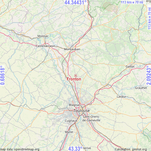
Fronton GPS coordinates[2]
43° 50' 21.516" North, 1° 23' 21.516" East
| Map corner | latitude | longitude |
|---|---|---|
| Upper-left | 44.34431°, | 0.68618° |
| Center: | 43.83931°, | 1.38931° |
| Lower-right: | 43.33°, | 2.09243° |
| Map W x H: | 112.8×112.8 km | = 70.1×70.1mi |
| max Lat: | 51.07786° ⇑88.7% North |
| Fronton: | 43.83931° |
| min Lat: | ⇓11.3% South 41.3874° |
| min Long | Fronton | max Long |
| -5.08615° | 1.38931° | 9.52242° |
| W 35.6%⇐ | ⇒64.4% E |
Elevation
Elevation of Fronton is 152 m = 499 ft, and this is 41.7 m = 137 ft below average elevation for this country.
| Max E: |
2333 m = 7654 ft | 44.4% |
| Avg. | 193.7 m = 635 ft | |
| Fronton | 152 m = 499 ft | |
Min E: |
-1 m = -3 ft | 55.6% |
See also: France elevation on elevation.city.
Geographical zone
Fronton is located in North temperate zone (between Tropic of Cancer and the Arctic Circle). Distance of this Northern Tropic circle is 2268.6 km =1409.6 mi to South.| Distance of | km | miles | from Fronton |
|---|---|---|---|
| North Pole | 5132.6 | 3189.2 | to North |
| Arctic Circle | 2526.7 | 1570 | to North |
| Tropic Cancer | 2268.6 | 1409.6 | to South |
| Equator | 4874.5 | 3028.9 | to South |


Nearby cities:
15 places around Fronton: (largest is in red/bold)
• Bouloc
6.5 km =4 mi,  168°
168°
• Campsas
8 km =5 mi,  321°
321°
• Canals
7.9 km =4.9 mi,  279°
279°
• Castelnau-d'Estrétefonds
6.6 km =4.1 mi,  201°
201°
• Grisolles
7.5 km =4.7 mi,  261°
261°
• Labastide-Saint-Pierre
8.9 km =5.5 mi,  348°
348°
• Nohic
6.8 km =4.2 mi,  34°
34°
• Ondes
9.1 km =5.7 mi,  225°
225°
• Orgueil
7.6 km =4.7 mi,  12°
12°
• Pompignan
6.6 km =4.1 mi,  248°
248°
• Reyniès
8.6 km =5.3 mi,  4°
4°
• Villaudric
3.5 km =2.2 mi,  106°
106°
• Villebrumier
9.4 km =5.8 mi, 34°
• Villemur-sur-Tarn
9.6 km =6 mi,  71°
71°
• Villeneuve-lès-Bouloc
8.4 km =5.2 mi,  161°
161°
Sources, notices
• [Note1] Compared only with cities in France existing in our database
• [Src1] Map data: © OpenStreetMap contributors (CC-BY-SA)
• [Src2] Other city data from geonames.org with taken over terms of usage.
• [Src3] Geographical zone / Annual Mean Temperature by Robert A. Rohde @ Wikipedia
