Pompignan geodata
Pompignan (Occitanie) is a populated place; located in France in Europe/Paris (GMT+2) time zone. With population of 1,076 people, there are 8284 cities with bigger population in this country. Compared to other cities in France, 89% of cities are located further ↑North; 65.4% of cities are located further →East and 53.3% of cities have higher elevation than Pompignan. Note1
Administrative division(s):
- Level 1: Occitanie
- Level 2: Département du Tarn-et-Garonne
- Level 3: Arrondissement de Montauban
- Level 4: Pompignan


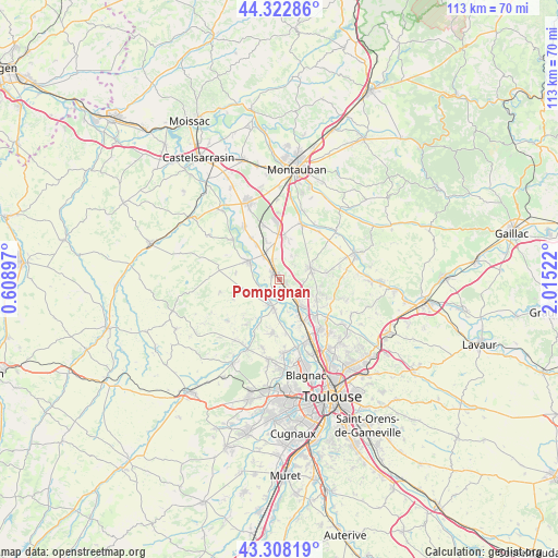
Pompignan GPS coordinates[2]
43° 49' 3.648" North, 1° 18' 43.524" East
| Map corner | latitude | longitude |
|---|---|---|
| Upper-left | 44.32286°, | 0.60897° |
| Center: | 43.81768°, | 1.31209° |
| Lower-right: | 43.30819°, | 2.01522° |
| Map W x H: | 112.8×112.8 km | = 70.1×70.1mi |
| max Lat: | 51.07786° ⇑89% North |
| Pompignan: | 43.81768° |
| min Lat: | ⇓11% South 41.3874° |
| min Long | Pompignan | max Long |
| -5.08615° | 1.31209° | 9.52242° |
| W 34.6%⇐ | ⇒65.4% E |
Elevation
Elevation of Pompignan is 121 m = 397 ft, and this is 72.7 m = 239 ft below average elevation for this country.
| Max E: |
2333 m = 7654 ft | 53.3% |
| Avg. | 193.7 m = 635 ft | |
| Pompignan | 121 m = 397 ft | |
Min E: |
-1 m = -3 ft | 46.7% |
See also: France elevation on elevation.city.
Geographical zone
Pompignan is located in North temperate zone (between Tropic of Cancer and the Arctic Circle). Distance of this Northern Tropic circle is 2266.2 km =1408.2 mi to South.| Distance of | km | miles | from Pompignan |
|---|---|---|---|
| North Pole | 5135 | 3190.7 | to North |
| Arctic Circle | 2529.1 | 1571.5 | to North |
| Tropic Cancer | 2266.2 | 1408.2 | to South |
| Equator | 4872.1 | 3027.4 | to South |


Nearby cities:
15 places around Pompignan: (largest is in red/bold)
• Aucamville
8 km =5 mi,  257°
257°
• Bessens
8.2 km =5.1 mi,  325°
325°
• Bouloc
8.5 km =5.3 mi,  118°
118°
• Campsas
8.8 km =5.5 mi,  7°
7°
• Canals
4.1 km =2.5 mi,  336°
336°
• Castelnau-d'Estrétefonds
5.3 km =3.3 mi,  135°
135°
• Dieupentale
6 km =3.7 mi, 325°
• Fronton
6.6 km =4.1 mi,  68°
68°
• Grenade
6.1 km =3.8 mi,  202°
202°
• Grisolles
1.8 km =1.1 mi,  316°
316°
• Ondes
3.9 km =2.4 mi,  184°
184°
• Saint-Jory
9.7 km =6 mi,  150°
150°
• Savenès
9.2 km =5.7 mi,  279°
279°
• Verdun-sur-Garonne
7.5 km =4.7 mi,  303°
303°
• Villaudric
9.7 km =6 mi,  81°
81°
Sources, notices
• [Note1] Compared only with cities in France existing in our database
• [Src1] Map data: © OpenStreetMap contributors (CC-BY-SA)
• [Src2] Other city data from geonames.org with taken over terms of usage.
• [Src3] Geographical zone / Annual Mean Temperature by Robert A. Rohde @ Wikipedia
