Campsas geodata
Campsas (Occitanie) is a populated place; located in France in Europe/Paris (GMT+2) time zone. With population of 1,043 people, there are 8513 cities with bigger population in this country. Compared to other cities in France, 88.1% of cities are located further ↑North; 65.3% of cities are located further →East and 50.6% of cities have lower elevation than Campsas. Note1
Administrative division(s):
- Level 1: Occitanie
- Level 2: Département du Tarn-et-Garonne
- Level 3: Arrondissement de Montauban
- Level 4: Campsas


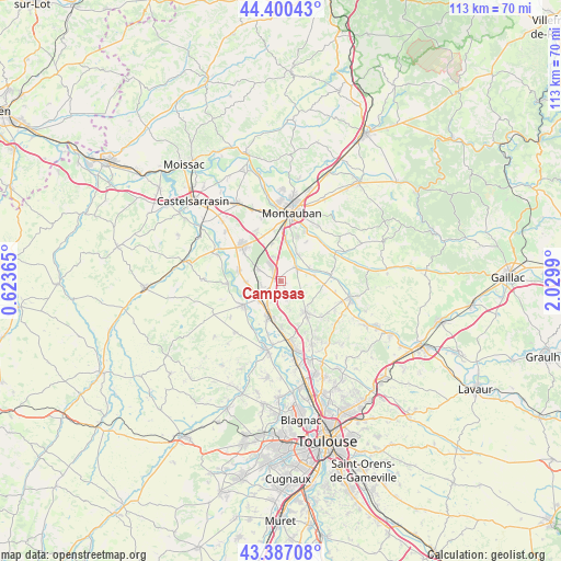
Campsas GPS coordinates[2]
43° 53' 45.276" North, 1° 19' 36.372" East
| Map corner | latitude | longitude |
|---|---|---|
| Upper-left | 44.40043°, | 0.62365° |
| Center: | 43.89591°, | 1.32677° |
| Lower-right: | 43.38708°, | 2.0299° |
| Map W x H: | 112.7×112.7 km | = 70×70mi |
| max Lat: | 51.07786° ⇑88.1% North |
| Campsas: | 43.89591° |
| min Lat: | ⇓11.9% South 41.3874° |
| min Long | Campsas | max Long |
| -5.08615° | 1.32677° | 9.52242° |
| W 34.7%⇐ | ⇒65.3% E |
Elevation
Elevation of Campsas is 134 m = 440 ft, and this is 59.7 m = 196 ft below average elevation for this country.
| Max E: |
2333 m = 7654 ft | 49.4% |
| Avg. | 193.7 m = 635 ft | |
| Campsas | 134 m = 440 ft | |
Min E: |
-1 m = -3 ft | 50.6% |
See also: France elevation on elevation.city.
Geographical zone
Campsas is located in North temperate zone (between Tropic of Cancer and the Arctic Circle). Distance of this Northern Tropic circle is 2274.8 km =1413.5 mi to South.| Distance of | km | miles | from Campsas |
|---|---|---|---|
| North Pole | 5126.3 | 3185.3 | to North |
| Arctic Circle | 2520.4 | 1566.1 | to North |
| Tropic Cancer | 2274.8 | 1413.5 | to South |
| Equator | 4880.8 | 3032.8 | to South |


Nearby cities:
15 places around Campsas: (largest is in red/bold)
• Bessens
6.2 km =3.9 mi,  251°
251°
• Bressols
8.1 km =5 mi,  6°
6°
• Canals
5.7 km =3.5 mi,  209°
209°
• Corbarieu
6.3 km =3.9 mi,  32°
32°
• Dieupentale
5.9 km =3.7 mi,  230°
230°
• Finhan
8.7 km =5.4 mi,  282°
282°
• Fronton
8 km =5 mi,  141°
141°
• Grisolles
7.8 km =4.8 mi,  197°
197°
• Labastide-Saint-Pierre
4 km =2.5 mi,  52°
52°
• Montbartier
4.6 km =2.9 mi,  295°
295°
• Nohic
8.9 km =5.5 mi,  94°
94°
• Orgueil
6.8 km =4.2 mi,  80°
80°
• Pompignan
8.8 km =5.5 mi,  187°
187°
• Reyniès
6.2 km =3.9 mi,  68°
68°
• Verdun-sur-Garonne
8.7 km =5.4 mi,  238°
238°
Sources, notices
• [Note1] Compared only with cities in France existing in our database
• [Src1] Map data: © OpenStreetMap contributors (CC-BY-SA)
• [Src2] Other city data from geonames.org with taken over terms of usage.
• [Src3] Geographical zone / Annual Mean Temperature by Robert A. Rohde @ Wikipedia
