Freigné geodata
Freigné (Pays de la Loire) is a populated place; located in France in Europe/Paris (GMT+2) time zone. With population of 1,045 people, there are 8501 cities with bigger population in this country. Compared to other cities in France, 52% of cities are located further ↓South; 89.4% of cities are located further →East and 81.5% of cities have higher elevation than Freigné. Note1
Administrative division(s):
- Level 1: Pays de la Loire
- Level 2: Loire-Atlantique
- Level 3: Arrondissement of Châteaubriant-Ancenis
- Level 4: Vallons-de-l'Erdre


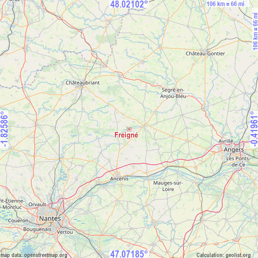
Freigné GPS coordinates[2]
47° 32' 54.888" North, 1° 7' 21.864" West
| Map corner | latitude | longitude |
|---|---|---|
| Upper-left | 48.02102°, | -1.82586° |
| Center: | 47.54858°, | -1.12274° |
| Lower-right: | 47.07185°, | -0.41961° |
| Map W x H: | 105.5×105.5 km | = 65.6×65.6mi |
| max Lat: | 51.07786° ⇑48% North |
| Freigné: | 47.54858° |
| min Lat: | ⇓52% South 41.3874° |
| min Long | Freigné | max Long |
| -5.08615° | -1.12274° | 9.52242° |
| W 10.6%⇐ | ⇒89.4% E |
Elevation
Elevation of Freigné is 51 m = 167 ft, and this is 142.7 m = 468 ft below average elevation for this country.
| Max E: |
2333 m = 7654 ft | 81.5% |
| Avg. | 193.7 m = 635 ft | |
| Freigné | 51 m = 167 ft | |
Min E: |
-1 m = -3 ft | 18.5% |
See also: France elevation on elevation.city.
Geographical zone
Freigné is located in North temperate zone (between Tropic of Cancer and the Arctic Circle). Distance of this North polar circle is 2114.3 km =1313.8 mi to North.| Distance of | km | miles | from Freigné |
|---|---|---|---|
| North Pole | 4720.2 | 2933 | to North |
| Arctic Circle | 2114.3 | 1313.8 | to North |
| Tropic Cancer | 2681 | 1665.9 | to South |
| Equator | 5286.9 | 3285.1 | to South |


Nearby cities:
15 places around Freigné: (largest is in red/bold)
• Angrie
11.5 km =7.1 mi,  77°
77°
• Belligné
11.5 km =7.1 mi,  141°
141°
• Bonnœuvre
8.5 km =5.3 mi,  258°
258°
• Candé
6.7 km =4.2 mi, 77°
• Challain-la-Potherie
11.3 km =7 mi,  30°
30°
• La Chapelle-Glain
9.8 km =6.1 mi,  326°
326°
• La Cornuaille
11.2 km =7 mi,  111°
111°
• La Roche-Blanche
12.1 km =7.5 mi,  186°
186°
• La Rouxière
12.5 km =7.8 mi,  160°
160°
• Maumusson
7.5 km =4.7 mi,  170°
170°
• Pannecé
11.2 km =7 mi,  231°
231°
• Pouillé-les-Côteaux
10.8 km =6.7 mi,  195°
195°
• Saint-Mars-la-Jaille
5.3 km =3.3 mi,  241°
241°
• Saint-Sulpice-des-Landes
7 km =4.3 mi,  295°
295°
• Vritz
5.4 km =3.4 mi,  47°
47°
Sources, notices
• [Note1] Compared only with cities in France existing in our database
• [Src1] Map data: © OpenStreetMap contributors (CC-BY-SA)
• [Src2] Other city data from geonames.org with taken over terms of usage.
• [Src3] Geographical zone / Annual Mean Temperature by Robert A. Rohde @ Wikipedia
