Fourqueux geodata
Fourqueux (Île-de-France) is a populated place; located in France in Europe/Paris (GMT+2) time zone. With population of 4,433 people, there are 2227 cities with bigger population in this country. Compared to other cities in France, 77.3% of cities are located further ↓South; 56.3% of cities are located further →East and 55.2% of cities have higher elevation than Fourqueux. Note1
Administrative division(s):
- Level 1: Île-de-France
- Level 2: Yvelines
- Level 3: Arrondissement de Saint-Germain-en-Laye
- Level 4: Saint-Germain-en-Laye


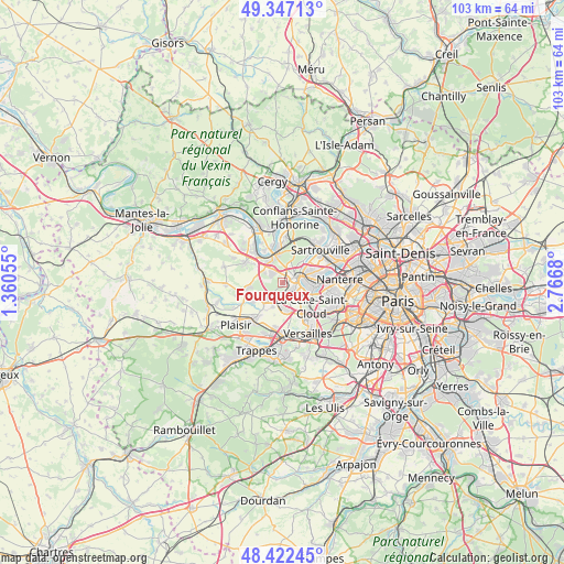
Fourqueux GPS coordinates[2]
48° 53' 12.948" North, 2° 3' 49.212" East
| Map corner | latitude | longitude |
|---|---|---|
| Upper-left | 49.34713°, | 1.36055° |
| Center: | 48.88693°, | 2.06367° |
| Lower-right: | 48.42245°, | 2.7668° |
| Map W x H: | 102.8×102.8 km | = 63.9×63.9mi |
| max Lat: | 51.07786° ⇑22.7% North |
| Fourqueux: | 48.88693° |
| min Lat: | ⇓77.3% South 41.3874° |
| min Long | Fourqueux | max Long |
| -5.08615° | 2.06367° | 9.52242° |
| W 43.7%⇐ | ⇒56.3% E |
Elevation
Elevation of Fourqueux is 116 m = 381 ft, and this is 77.7 m = 255 ft below average elevation for this country.
| Max E: |
2333 m = 7654 ft | 55.2% |
| Avg. | 193.7 m = 635 ft | |
| Fourqueux | 116 m = 381 ft | |
Min E: |
-1 m = -3 ft | 44.8% |
See also: France elevation on elevation.city.
Geographical zone
Fourqueux is located in North temperate zone (between Tropic of Cancer and the Arctic Circle). Distance of this North polar circle is 1965.5 km =1221.3 mi to North.| Distance of | km | miles | from Fourqueux |
|---|---|---|---|
| North Pole | 4571.3 | 2840.5 | to North |
| Arctic Circle | 1965.5 | 1221.3 | to North |
| Tropic Cancer | 2829.8 | 1758.4 | to South |
| Equator | 5435.7 | 3377.6 | to South |


Nearby cities:
15 places around Fourqueux: (largest is in red/bold)
• Aigremont
3.8 km =2.4 mi,  300°
300°
• Bailly
5.1 km =3.2 mi,  169°
169°
• Chambourcy
2.7 km =1.7 mi,  322°
322°
• Croissy-sur-Seine
5.5 km =3.4 mi,  98°
98°
• Le Pecq
3 km =1.9 mi,  76°
76°
• Le Port-Marly
3.5 km =2.2 mi, 84°
• Le Vésinet
5.1 km =3.2 mi, 82°
• Louveciennes
4.7 km =2.9 mi,  127°
127°
• L’Étang-la-Ville
2 km =1.2 mi,  193°
193°
• Mareil-Marly
0.9 km =0.6 mi, 126°
• Marly-le-Roi
2.7 km =1.7 mi,  147°
147°
• Noisy-le-Roi
4.7 km =2.9 mi,  180°
180°
• Poissy
4.8 km =3 mi,  347°
347°
• Saint-Germain-en-Laye
2.2 km =1.4 mi,  61°
61°
• Saint-Nom-la-Bretêche
4.3 km =2.7 mi,  224°
224°
Sources, notices
• [Note1] Compared only with cities in France existing in our database
• [Src1] Map data: © OpenStreetMap contributors (CC-BY-SA)
• [Src2] Other city data from geonames.org with taken over terms of usage.
• [Src3] Geographical zone / Annual Mean Temperature by Robert A. Rohde @ Wikipedia
