Saint-Germain-en-Laye geodata
Saint-Germain-en-Laye (Île-de-France) is a seat of a third-order administrative division; located in France in Europe/Paris (GMT+2) time zone. With population of 41,142 people, there are 174 cities with bigger population in this country. Compared to other cities in France, 77.5% of cities are located further ↓South; 55.9% of cities are located further →East and 65.6% of cities have higher elevation than Saint-Germain-en-Laye. Note1
Administrative division(s):
- Level 1: Île-de-France
- Level 2: Yvelines
- Level 3: Arrondissement de Saint-Germain-en-Laye
- Level 4: Saint-Germain-en-Laye


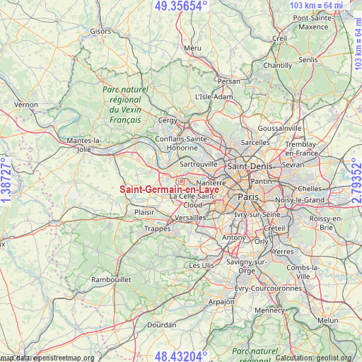
Saint-Germain-en-Laye GPS coordinates[2]
48° 53' 47.148" North, 2° 5' 25.44" East
| Map corner | latitude | longitude |
|---|---|---|
| Upper-left | 49.35654°, | 1.38727° |
| Center: | 48.89643°, | 2.0904° |
| Lower-right: | 48.43204°, | 2.79352° |
| Map W x H: | 102.8×102.8 km | = 63.9×63.9mi |
| max Lat: | 51.07786° ⇑22.5% North |
| Saint-Germain-en-Laye: | 48.89643° |
| min Lat: | ⇓77.5% South 41.3874° |
| min Long | Saint-Germain-e | max Long |
| -5.08615° | 2.0904° | 9.52242° |
| W 44.1%⇐ | ⇒55.9% E |
Elevation
Elevation of Saint-Germain-en-Laye is 88 m = 289 ft, and this is 105.7 m = 347 ft below average elevation for this country.
| Max E: |
2333 m = 7654 ft | 65.6% |
| Avg. | 193.7 m = 635 ft | |
| Saint-Germain-en-Laye | 88 m = 289 ft | |
Min E: |
-1 m = -3 ft | 34.4% |
See also: Saint-Germain-en-Laye elevation on elevation.city.
Geographical zone
Saint-Germain-en-Laye is located in North temperate zone (between Tropic of Cancer and the Arctic Circle). Distance of this North polar circle is 1964.4 km =1220.6 mi to North.| Distance of | km | miles | from Saint-Germain-en-Laye |
|---|---|---|---|
| North Pole | 4570.3 | 2839.9 | to North |
| Arctic Circle | 1964.4 | 1220.6 | to North |
| Tropic Cancer | 2830.9 | 1759 | to South |
| Equator | 5436.8 | 3378.3 | to South |


Nearby cities:
15 places around Saint-Germain-en-Laye: (largest is in red/bold)
• Bougival
5.3 km =3.3 mi,  135°
135°
• Chambourcy
3.8 km =2.4 mi,  287°
287°
• Chatou
5 km =3.1 mi,  98°
98°
• Croissy-sur-Seine
4 km =2.5 mi,  118°
118°
• Fourqueux
2.2 km =1.4 mi,  241°
241°
• Le Mesnil-le-Roi
5.3 km =3.3 mi,  28°
28°
• Le Pecq
1 km =0.6 mi,  110°
110°
• Le Port-Marly
1.7 km =1.1 mi, 114°
• Le Vésinet
3.1 km =1.9 mi, 97°
• Louveciennes
4.3 km =2.7 mi,  155°
155°
• L’Étang-la-Ville
3.8 km =2.4 mi,  218°
218°
• Mareil-Marly
2 km =1.2 mi, 217°
• Marly-le-Roi
3.3 km =2.1 mi,  188°
188°
• Montesson
3.7 km =2.3 mi,  67°
67°
• Poissy
4.7 km =2.9 mi,  320°
320°
Sources, notices
• [Note1] Compared only with cities in France existing in our database
• [Src1] Map data: © OpenStreetMap contributors (CC-BY-SA)
• [Src2] Other city data from geonames.org with taken over terms of usage.
• [Src3] Geographical zone / Annual Mean Temperature by Robert A. Rohde @ Wikipedia
