Boyard-Ville geodata
Boyard-Ville (Nouvelle-Aquitaine) is a populated place; located in France in Europe/Paris (GMT+2) time zone. With population of 2,991 people, there are 3261 cities with bigger population in this country. Compared to other cities in France, 66.6% of cities are located further ↑North; 90.3% of cities are located further →East and 99.8% of cities have higher elevation than Boyard-Ville. Note1
Administrative division(s):
- Level 1: Nouvelle-Aquitaine
- Level 2: Charente-Maritime
- Level 3: Arrondissement de Rochefort
- Level 4: Saint-Georges-d'Oléron


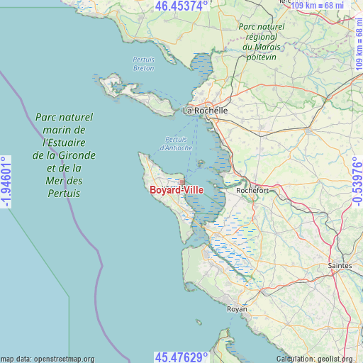
Boyard-Ville GPS coordinates[2]
45° 58' 1.812" North, 1° 14' 34.404" West
| Map corner | latitude | longitude |
|---|---|---|
| Upper-left | 46.45374°, | -1.94601° |
| Center: | 45.96717°, | -1.24289° |
| Lower-right: | 45.47629°, | -0.53976° |
| Map W x H: | 108.7×108.7 km | = 67.5×67.5mi |
| max Lat: | 51.07786° ⇑66.6% North |
| Boyard-Ville: | 45.96717° |
| min Lat: | ⇓33.4% South 41.3874° |
| min Long | Boyard-Ville | max Long |
| -5.08615° | -1.24289° | 9.52242° |
| W 9.7%⇐ | ⇒90.3% E |
Elevation
Elevation of Boyard-Ville is 3 m = 10 ft, and this is 190.7 m = 626 ft below average elevation for this country.
| Max E: |
2333 m = 7654 ft | 99.8% |
| Avg. | 193.7 m = 635 ft | |
| Boyard-Ville | 3 m = 10 ft | |
Min E: |
-1 m = -3 ft | 0.2% |
See also: France elevation on elevation.city.
Geographical zone
Boyard-Ville is located in North temperate zone (between Tropic of Cancer and the Arctic Circle). Distance of this North polar circle is 2290.1 km =1423 mi to North.| Distance of | km | miles | from Boyard-Ville |
|---|---|---|---|
| North Pole | 4896 | 3042.2 | to North |
| Arctic Circle | 2290.1 | 1423 | to North |
| Tropic Cancer | 2505.2 | 1556.7 | to South |
| Equator | 5111.1 | 3175.9 | to South |


Nearby cities:
15 places around Boyard-Ville: (largest is in red/bold)
• Angoulins
18.6 km =11.6 mi,  34°
34°
• Bourcefranc-le-Chapus
14.9 km =9.3 mi,  151°
151°
• Châtelaillon-Plage
16.6 km =10.3 mi,  45°
45°
• Dolus-d'Oléron
5.9 km =3.7 mi,  198°
198°
• Fouras
11.8 km =7.3 mi,  79°
79°
• La Brée-les-Bains
9.8 km =6.1 mi,  303°
303°
• Le Grand-Village-Plage
11.2 km =7 mi,  176°
176°
• Moëze
17.5 km =10.9 mi,  113°
113°
• Port-des-Barques
12.9 km =8 mi,  99°
99°
• Saint-Denis-d’Oléron
12.9 km =8 mi,  305°
305°
• Saint-Laurent-de-la-Prée
16.1 km =10 mi, 83°
• Saint-Nazaire-sur-Charente
15.1 km =9.4 mi, 103°
• Saint-Pierre-d’Oléron
5.5 km =3.4 mi,  242°
242°
• Saint-Trojan-les-Bains
14.3 km =8.9 mi,  168°
168°
• Yves
16.1 km =10 mi,  68°
68°
Sources, notices
• [Note1] Compared only with cities in France existing in our database
• [Src1] Map data: © OpenStreetMap contributors (CC-BY-SA)
• [Src2] Other city data from geonames.org with taken over terms of usage.
• [Src3] Geographical zone / Annual Mean Temperature by Robert A. Rohde @ Wikipedia
