Formerie geodata
Formerie (Hauts-de-France) is a populated place; located in France in Europe/Paris (GMT+2) time zone. With population of 2,272 people, there are 4238 cities with bigger population in this country. Compared to other cities in France, 91.1% of cities are located further ↓South; 60.1% of cities are located further →East and 71.4% of cities have lower elevation than Formerie. Note1
Administrative division(s):
- Level 1: Hauts-de-France
- Level 2: Département de l'Oise
- Level 3: Arrondissement de Beauvais
- Level 4: Formerie


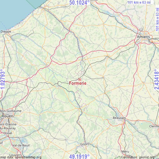
Formerie GPS coordinates[2]
49° 38' 57.408" North, 1° 43' 51.816" East
| Map corner | latitude | longitude |
|---|---|---|
| Upper-left | 50.1024°, | 1.02793° |
| Center: | 49.64928°, | 1.73106° |
| Lower-right: | 49.1919°, | 2.43418° |
| Map W x H: | 101.2×101.2 km | = 62.9×62.9mi |
| max Lat: | 51.07786° ⇑8.9% North |
| Formerie: | 49.64928° |
| min Lat: | ⇓91.1% South 41.3874° |
| min Long | Formerie | max Long |
| -5.08615° | 1.73106° | 9.52242° |
| W 39.9%⇐ | ⇒60.1% E |
Elevation
Elevation of Formerie is 226 m = 741 ft, and this is 32.3 m = 106 ft above average elevation for this country.
| Max E: |
2333 m = 7654 ft | 28.6% |
| Formerie | 226 m 741 ft | |
| Avg. | 193.7 m = 635 ft | |
Min E: |
-1 m = -3 ft | 71.4% |
See also: France elevation on elevation.city.
Geographical zone
Formerie is located in North temperate zone (between Tropic of Cancer and the Arctic Circle). Distance of this North polar circle is 1880.7 km =1168.6 mi to North.| Distance of | km | miles | from Formerie |
|---|---|---|---|
| North Pole | 4486.6 | 2787.8 | to North |
| Arctic Circle | 1880.7 | 1168.6 | to North |
| Tropic Cancer | 2914.6 | 1811 | to South |
| Equator | 5520.5 | 3430.3 | to South |


Nearby cities:
15 places around Formerie: (largest is in red/bold)
• Abancourt
5.8 km =3.6 mi,  25°
25°
• Aumale
13.5 km =8.4 mi,  7°
7°
• Boutavent
8 km =5 mi,  142°
142°
• Cempuis
18.8 km =11.7 mi,  86°
86°
• Feuquières
8.4 km =5.2 mi, 91°
• Forges-les-Eaux
14 km =8.7 mi,  253°
253°
• Gaillefontaine
8.3 km =5.2 mi,  273°
273°
• Gournay-en-Bray
18.5 km =11.5 mi,  181°
181°
• Grandvilliers
15.2 km =9.4 mi,  83°
83°
• Hanvoile
18.9 km =11.7 mi, 144°
• Marseille-en-Beauvaisis
18.1 km =11.2 mi,  116°
116°
• Moliens
6 km =3.7 mi,  71°
71°
• Romescamps
8.7 km =5.4 mi,  37°
37°
• Serqueux
13.9 km =8.6 mi,  262°
262°
• Songeons
14.2 km =8.8 mi, 141°
Sources, notices
• [Note1] Compared only with cities in France existing in our database
• [Src1] Map data: © OpenStreetMap contributors (CC-BY-SA)
• [Src2] Other city data from geonames.org with taken over terms of usage.
• [Src3] Geographical zone / Annual Mean Temperature by Robert A. Rohde @ Wikipedia
