Grandvilliers geodata
Grandvilliers (Hauts-de-France) is a populated place; located in France in Europe/Paris (GMT+2) time zone. With population of 3,013 people, there are 3238 cities with bigger population in this country. Compared to other cities in France, 91.2% of cities are located further ↓South; 57.8% of cities are located further →East and 65.4% of cities have lower elevation than Grandvilliers. Note1
Administrative division(s):
- Level 1: Hauts-de-France
- Level 2: Département de l'Oise
- Level 3: Arrondissement de Beauvais
- Level 4: Grandvilliers


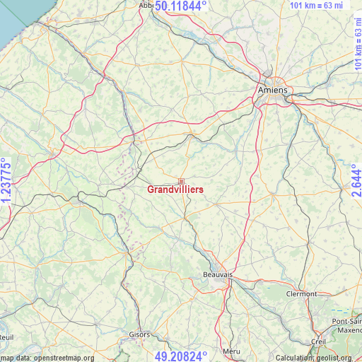
Grandvilliers GPS coordinates[2]
49° 39' 55.692" North, 1° 56' 27.168" East
| Map corner | latitude | longitude |
|---|---|---|
| Upper-left | 50.11844°, | 1.23775° |
| Center: | 49.66547°, | 1.94088° |
| Lower-right: | 49.20824°, | 2.644° |
| Map W x H: | 101.2×101.2 km | = 62.9×62.9mi |
| max Lat: | 51.07786° ⇑8.8% North |
| Grandvilliers: | 49.66547° |
| min Lat: | ⇓91.2% South 41.3874° |
| min Long | Grandvilliers | max Long |
| -5.08615° | 1.94088° | 9.52242° |
| W 42.2%⇐ | ⇒57.8% E |
Elevation
Elevation of Grandvilliers is 196 m = 643 ft, and this is 2.3 m = 8 ft above average elevation for this country.
| Max E: |
2333 m = 7654 ft | 34.6% |
| Grandvilliers | 196 m 643 ft | |
| Avg. | 193.7 m = 635 ft | |
Min E: |
-1 m = -3 ft | 65.4% |
See also: France elevation on elevation.city.
Geographical zone
Grandvilliers is located in North temperate zone (between Tropic of Cancer and the Arctic Circle). Distance of this North polar circle is 1878.9 km =1167.5 mi to North.| Distance of | km | miles | from Grandvilliers |
|---|---|---|---|
| North Pole | 4484.8 | 2786.7 | to North |
| Arctic Circle | 1878.9 | 1167.5 | to North |
| Tropic Cancer | 2916.4 | 1812.2 | to South |
| Equator | 5522.3 | 3431.4 | to South |


Nearby cities:
15 places around Grandvilliers: (largest is in red/bold)
• Abancourt
13.1 km =8.1 mi,  285°
285°
• Aumale
17.7 km =11 mi,  311°
311°
• Boutavent
13 km =8.1 mi,  231°
231°
• Cempuis
3.7 km =2.3 mi,  100°
100°
• Conty
17.3 km =10.7 mi,  60°
60°
• Crèvecœur-le-Grand
12.6 km =7.8 mi,  125°
125°
• Feuquières
7 km =4.3 mi,  252°
252°
• Formerie
15.2 km =9.4 mi,  263°
263°
• Luchy
17.7 km =11 mi, 133°
• Marseille-en-Beauvaisis
10 km =6.2 mi,  174°
174°
• Moliens
9.4 km =5.8 mi,  270°
270°
• Poix-de-Picardie
13.5 km =8.4 mi,  13°
13°
• Romescamps
11 km =6.8 mi,  297°
297°
• Saint-Omer-en-Chaussée
15.6 km =9.7 mi,  163°
163°
• Songeons
14.4 km =8.9 mi,  205°
205°
Sources, notices
• [Note1] Compared only with cities in France existing in our database
• [Src1] Map data: © OpenStreetMap contributors (CC-BY-SA)
• [Src2] Other city data from geonames.org with taken over terms of usage.
• [Src3] Geographical zone / Annual Mean Temperature by Robert A. Rohde @ Wikipedia
