Serqueux geodata
Serqueux (Normandy) is a populated place; located in France in Europe/Paris (GMT+2) time zone. With population of 1,016 people, there are 8720 cities with bigger population in this country. Compared to other cities in France, 90.9% of cities are located further ↓South; 62.5% of cities are located further →East and 59.3% of cities have lower elevation than Serqueux. Note1
Administrative division(s):
- Level 1: Normandy
- Level 2: Seine-Maritime
- Level 3: Arrondissement de Dieppe
- Level 4: Serqueux


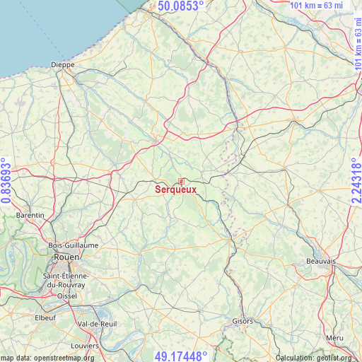
Serqueux GPS coordinates[2]
49° 37' 55.272" North, 1° 32' 24.18" East
| Map corner | latitude | longitude |
|---|---|---|
| Upper-left | 50.0853°, | 0.83693° |
| Center: | 49.63202°, | 1.54005° |
| Lower-right: | 49.17448°, | 2.24318° |
| Map W x H: | 101.3×101.3 km | = 62.9×62.9mi |
| max Lat: | 51.07786° ⇑9.1% North |
| Serqueux: | 49.63202° |
| min Lat: | ⇓90.9% South 41.3874° |
| min Long | Serqueux | max Long |
| -5.08615° | 1.54005° | 9.52242° |
| W 37.5%⇐ | ⇒62.5% E |
Elevation
Elevation of Serqueux is 167 m = 548 ft, and this is 26.7 m = 88 ft below average elevation for this country.
| Max E: |
2333 m = 7654 ft | 40.7% |
| Avg. | 193.7 m = 635 ft | |
| Serqueux | 167 m = 548 ft | |
Min E: |
-1 m = -3 ft | 59.3% |
See also: France elevation on elevation.city.
Geographical zone
Serqueux is located in North temperate zone (between Tropic of Cancer and the Arctic Circle). Distance of this North polar circle is 1882.6 km =1169.8 mi to North.| Distance of | km | miles | from Serqueux |
|---|---|---|---|
| North Pole | 4488.5 | 2789 | to North |
| Arctic Circle | 1882.6 | 1169.8 | to North |
| Tropic Cancer | 2912.6 | 1809.8 | to South |
| Equator | 5518.6 | 3429.1 | to South |


Nearby cities:
15 places around Serqueux: (largest is in red/bold)
• Abancourt
17.7 km =11 mi,  66°
66°
• Buchy
14.1 km =8.8 mi,  248°
248°
• Bully
16.2 km =10.1 mi,  310°
310°
• Estouteville-Écalles
16.9 km =10.5 mi, 254°
• Forges-les-Eaux
2 km =1.2 mi,  170°
170°
• Formerie
13.9 km =8.6 mi,  82°
82°
• Gaillefontaine
5.9 km =3.7 mi, 66°
• Montérolier
13.9 km =8.6 mi,  269°
269°
• Neufchâtel-en-Bray
13.4 km =8.3 mi,  327°
327°
• Neuville-Ferrières
10.7 km =6.6 mi, 326°
• Saint-Lucien
15.2 km =9.4 mi,  205°
205°
• Saint-Martin-Osmonville
17.3 km =10.7 mi, 272°
• Sainte-Croix-sur-Buchy
15.6 km =9.7 mi,  241°
241°
• Sigy-en-Bray
10.2 km =6.3 mi,  201°
201°
• Sommery
7.1 km =4.4 mi, 272°
Sources, notices
• [Note1] Compared only with cities in France existing in our database
• [Src1] Map data: © OpenStreetMap contributors (CC-BY-SA)
• [Src2] Other city data from geonames.org with taken over terms of usage.
• [Src3] Geographical zone / Annual Mean Temperature by Robert A. Rohde @ Wikipedia
