Gournay-en-Bray geodata
Gournay-en-Bray (Normandy) is a populated place; located in France in Europe/Paris (GMT+2) time zone. With population of 6,449 people, there are 1534 cities with bigger population in this country. Compared to other cities in France, 89% of cities are located further ↓South; 60.2% of cities are located further →East and 61.2% of cities have higher elevation than Gournay-en-Bray. Note1
Administrative division(s):
- Level 1: Normandy
- Level 2: Seine-Maritime
- Level 3: Arrondissement de Dieppe
- Level 4: Gournay-en-Bray


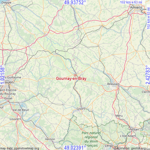
Gournay-en-Bray GPS coordinates[2]
49° 28' 58.26" North, 1° 43' 28.956" East
| Map corner | latitude | longitude |
|---|---|---|
| Upper-left | 49.93752°, | 1.02158° |
| Center: | 49.48285°, | 1.72471° |
| Lower-right: | 49.02391°, | 2.42783° |
| Map W x H: | 101.6×101.6 km | = 63.1×63.1mi |
| max Lat: | 51.07786° ⇑11% North |
| Gournay-en-Bray: | 49.48285° |
| min Lat: | ⇓89% South 41.3874° |
| min Long | Gournay-en-Bray | max Long |
| -5.08615° | 1.72471° | 9.52242° |
| W 39.8%⇐ | ⇒60.2% E |
Elevation
Elevation of Gournay-en-Bray is 99 m = 325 ft, and this is 94.7 m = 311 ft below average elevation for this country.
| Max E: |
2333 m = 7654 ft | 61.2% |
| Avg. | 193.7 m = 635 ft | |
| Gournay-en-Bray | 99 m = 325 ft | |
Min E: |
-1 m = -3 ft | 38.8% |
See also: France elevation on elevation.city.
Geographical zone
Gournay-en-Bray is located in North temperate zone (between Tropic of Cancer and the Arctic Circle). Distance of this North polar circle is 1899.2 km =1180.1 mi to North.| Distance of | km | miles | from Gournay-en-Bray |
|---|---|---|---|
| North Pole | 4505.1 | 2799.3 | to North |
| Arctic Circle | 1899.2 | 1180.1 | to North |
| Tropic Cancer | 2896.1 | 1799.6 | to South |
| Equator | 5502 | 3418.8 | to South |


Nearby cities:
15 places around Gournay-en-Bray: (largest is in red/bold)
• Boutavent
13.4 km =8.3 mi,  23°
23°
• Cuigy-en-Bray
9.7 km =6 mi,  130°
130°
• Hanvoile
11.8 km =7.3 mi,  75°
75°
• Hébécourt
14.4 km =8.9 mi,  179°
179°
• La Feuillie
15.3 km =9.5 mi,  262°
262°
• Lachapelle-aux-Pots
13.4 km =8.3 mi,  106°
106°
• Lalande-en-Son
11 km =6.8 mi,  157°
157°
• Le Coudray-Saint-Germer
11.4 km =7.1 mi, 133°
• Longchamps
15.3 km =9.5 mi,  208°
208°
• Saint-Aubin-en-Bray
13.1 km =8.1 mi,  122°
122°
• Saint-Germer-de-Fly
6 km =3.7 mi,  138°
138°
• Senantes
8 km =5 mi,  87°
87°
• Songeons
11.9 km =7.4 mi,  51°
51°
• Sérifontaine
14.6 km =9.1 mi,  167°
167°
• Talmontiers
11 km =6.8 mi, 173°
Sources, notices
• [Note1] Compared only with cities in France existing in our database
• [Src1] Map data: © OpenStreetMap contributors (CC-BY-SA)
• [Src2] Other city data from geonames.org with taken over terms of usage.
• [Src3] Geographical zone / Annual Mean Temperature by Robert A. Rohde @ Wikipedia
