Febvin-Palfart geodata
Febvin-Palfart (Hauts-de-France) is a populated place; located in France in Europe/Paris (GMT+2) time zone. With population of 508 people, there are 15076 cities with bigger population in this country. Compared to other cities in France, 97.6% of cities are located further ↓South; 52.5% of cities are located further →East and 52.3% of cities have higher elevation than Febvin-Palfart. Note1
Administrative division(s):
- Level 1: Hauts-de-France
- Level 2: Pas-de-Calais
- Level 3: Arrondissement de Saint-Omer
- Level 4: Febvin-Palfart


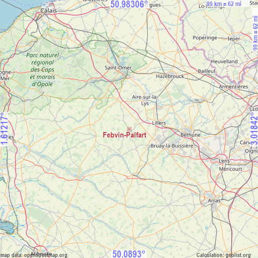
Febvin-Palfart GPS coordinates[2]
50° 32' 17.88" North, 2° 18' 55.044" East
| Map corner | latitude | longitude |
|---|---|---|
| Upper-left | 50.98306°, | 1.61217° |
| Center: | 50.5383°, | 2.31529° |
| Lower-right: | 50.0893°, | 3.01842° |
| Map W x H: | 99.4×99.4 km | = 61.8×61.8mi |
| max Lat: | 51.07786° ⇑2.4% North |
| Febvin-Palfart: | 50.5383° |
| min Lat: | ⇓97.6% South 41.3874° |
| min Long | Febvin-Palfart | max Long |
| -5.08615° | 2.31529° | 9.52242° |
| W 47.5%⇐ | ⇒52.5% E |
Elevation
Elevation of Febvin-Palfart is 124 m = 407 ft, and this is 69.7 m = 229 ft below average elevation for this country.
| Max E: |
2333 m = 7654 ft | 52.3% |
| Avg. | 193.7 m = 635 ft | |
| Febvin-Palfart | 124 m = 407 ft | |
Min E: |
-1 m = -3 ft | 47.7% |
See also: France elevation on elevation.city.
Geographical zone
Febvin-Palfart is located in North temperate zone (between Tropic of Cancer and the Arctic Circle). Distance of this North polar circle is 1781.8 km =1107.2 mi to North.| Distance of | km | miles | from Febvin-Palfart |
|---|---|---|---|
| North Pole | 4387.7 | 2726.4 | to North |
| Arctic Circle | 1781.8 | 1107.2 | to North |
| Tropic Cancer | 3013.4 | 1872.4 | to South |
| Equator | 5619.3 | 3491.7 | to South |


Nearby cities:
15 places around Febvin-Palfart: (largest is in red/bold)
• Ames
7.1 km =4.4 mi,  87°
87°
• Blessy
8.8 km =5.5 mi,  7°
7°
• Bomy
6.9 km =4.3 mi,  304°
304°
• Bourecq
9.1 km =5.7 mi,  65°
65°
• Enquin-les-Mines
5.9 km =3.7 mi,  337°
337°
• Estrée-Blanche
6.2 km =3.9 mi,  3°
3°
• Ferfay
8 km =5 mi,  105°
105°
• Floringhem
9.1 km =5.7 mi,  121°
121°
• Heuchin
7.7 km =4.8 mi,  204°
204°
• Ligny-lès-Aire
3.2 km =2 mi,  48°
48°
• Lisbourg
7.8 km =4.8 mi,  243°
243°
• Norrent-Fontes
7.8 km =4.8 mi, 50°
• Pernes
9.1 km =5.7 mi,  131°
131°
• Saint-Hilaire-Cottes
7.8 km =4.8 mi,  62°
62°
• Witternesse
8.5 km =5.3 mi,  22°
22°
Sources, notices
• [Note1] Compared only with cities in France existing in our database
• [Src1] Map data: © OpenStreetMap contributors (CC-BY-SA)
• [Src2] Other city data from geonames.org with taken over terms of usage.
• [Src3] Geographical zone / Annual Mean Temperature by Robert A. Rohde @ Wikipedia
