Lisbourg geodata
Lisbourg (Hauts-de-France) is a populated place; located in France in Europe/Paris (GMT+2) time zone. With population of 602 people, there are 13285 cities with bigger population in this country. Compared to other cities in France, 97.4% of cities are located further ↓South; 54.1% of cities are located further →East and 54.4% of cities have higher elevation than Lisbourg. Note1
Administrative division(s):
- Level 1: Hauts-de-France
- Level 2: Pas-de-Calais
- Level 3: Arras
- Level 4: Lisbourg


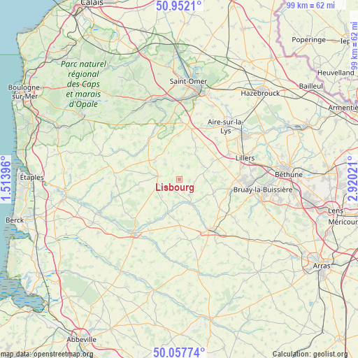
Lisbourg GPS coordinates[2]
50° 30' 25.344" North, 2° 13' 1.488" East
| Map corner | latitude | longitude |
|---|---|---|
| Upper-left | 50.9521°, | 1.51396° |
| Center: | 50.50704°, | 2.21708° |
| Lower-right: | 50.05774°, | 2.92021° |
| Map W x H: | 99.4×99.4 km | = 61.8×61.8mi |
| max Lat: | 51.07786° ⇑2.6% North |
| Lisbourg: | 50.50704° |
| min Lat: | ⇓97.4% South 41.3874° |
| min Long | Lisbourg | max Long |
| -5.08615° | 2.21708° | 9.52242° |
| W 45.9%⇐ | ⇒54.1% E |
Elevation
Elevation of Lisbourg is 118 m = 387 ft, and this is 75.7 m = 248 ft below average elevation for this country.
| Max E: |
2333 m = 7654 ft | 54.4% |
| Avg. | 193.7 m = 635 ft | |
| Lisbourg | 118 m = 387 ft | |
Min E: |
-1 m = -3 ft | 45.6% |
See also: France elevation on elevation.city.
Geographical zone
Lisbourg is located in North temperate zone (between Tropic of Cancer and the Arctic Circle). Distance of this North polar circle is 1785.3 km =1109.3 mi to North.| Distance of | km | miles | from Lisbourg |
|---|---|---|---|
| North Pole | 4391.2 | 2728.6 | to North |
| Arctic Circle | 1785.3 | 1109.3 | to North |
| Tropic Cancer | 3009.9 | 1870.3 | to South |
| Equator | 5615.9 | 3489.6 | to South |


Nearby cities:
15 places around Lisbourg: (largest is in red/bold)
• Anvin
7.2 km =4.5 mi,  158°
158°
• Audincthun
10.3 km =6.4 mi,  325°
325°
• Blangy-sur-Ternoise
10.1 km =6.3 mi,  199°
199°
• Bomy
7.5 km =4.7 mi,  9°
9°
• Coupelle-Vieille
8.5 km =5.3 mi,  282°
282°
• Coyecques
11 km =6.8 mi,  347°
347°
• Créquy
11.6 km =7.2 mi,  262°
262°
• Delettes
12.3 km =7.6 mi,  358°
358°
• Enquin-les-Mines
10.1 km =6.3 mi,  27°
27°
• Estrée-Blanche
12.1 km =7.5 mi,  37°
37°
• Febvin-Palfart
7.8 km =4.8 mi,  63°
63°
• Fruges
6 km =3.7 mi, 278°
• Heuchin
5.1 km =3.2 mi,  133°
133°
• Ligny-lès-Aire
10.9 km =6.8 mi, 59°
• Wailly
10.7 km =6.6 mi, 279°
Sources, notices
• [Note1] Compared only with cities in France existing in our database
• [Src1] Map data: © OpenStreetMap contributors (CC-BY-SA)
• [Src2] Other city data from geonames.org with taken over terms of usage.
• [Src3] Geographical zone / Annual Mean Temperature by Robert A. Rohde @ Wikipedia
