Lacapelle-Marival geodata
Lacapelle-Marival (Occitanie) is a populated place; located in France in Europe/Paris (GMT+2) time zone. With population of 1,360 people, there are 6763 cities with bigger population in this country. Compared to other cities in France, 81.9% of cities are located further ↑North; 58% of cities are located further →East and 87.1% of cities have lower elevation than Lacapelle-Marival. Note1
Administrative division(s):
- Level 1: Occitanie
- Level 2: Lot
- Level 3: Arrondissement de Figeac
- Level 4: Lacapelle-Marival


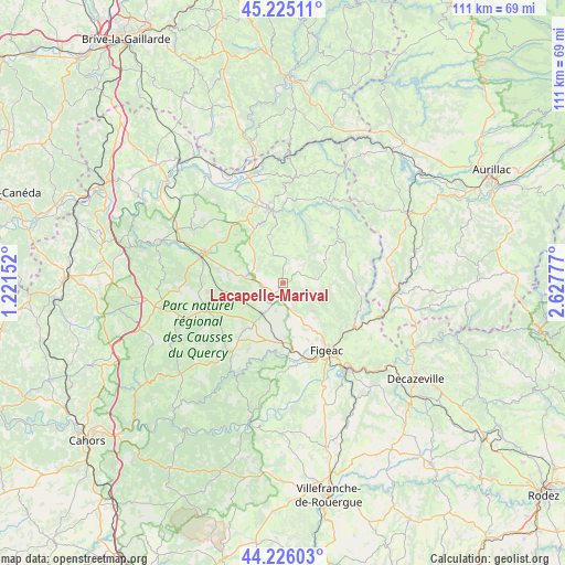
Lacapelle-Marival GPS coordinates[2]
44° 43' 39.828" North, 1° 55' 28.74" East
| Map corner | latitude | longitude |
|---|---|---|
| Upper-left | 45.22511°, | 1.22152° |
| Center: | 44.72773°, | 1.92465° |
| Lower-right: | 44.22603°, | 2.62777° |
| Map W x H: | 111.1×111.1 km | = 69×69mi |
| max Lat: | 51.07786° ⇑81.9% North |
| Lacapelle-Marival: | 44.72773° |
| min Lat: | ⇓18.1% South 41.3874° |
| min Long | Lacapelle-Mariv | max Long |
| -5.08615° | 1.92465° | 9.52242° |
| W 42%⇐ | ⇒58% E |
Elevation
Elevation of Lacapelle-Marival is 376 m = 1234 ft, and this is 182.3 m = 598 ft above average elevation for this country.
| Max E: |
2333 m = 7654 ft | 12.9% |
| Lacapelle-Marival | 376 m 1234 ft | |
| Avg. | 193.7 m = 635 ft | |
Min E: |
-1 m = -3 ft | 87.1% |
See also: France elevation on elevation.city.
Geographical zone
Lacapelle-Marival is located in North temperate zone (between Tropic of Cancer and the Arctic Circle). Distance of this Northern Tropic circle is 2367.3 km =1471 mi to South.| Distance of | km | miles | from Lacapelle-Marival |
|---|---|---|---|
| North Pole | 5033.8 | 3127.9 | to North |
| Arctic Circle | 2427.9 | 1508.6 | to North |
| Tropic Cancer | 2367.3 | 1471 | to South |
| Equator | 4973.3 | 3090.3 | to South |


Nearby cities:
15 places around Lacapelle-Marival: (largest is in red/bold)
• Assier
7 km =4.3 mi,  212°
212°
• Aynac
8.5 km =5.3 mi,  317°
317°
• Bagnac-sur-Célé
20.3 km =12.6 mi,  109°
109°
• Béduer
16.4 km =10.2 mi,  173°
173°
• Cardaillac
7.9 km =4.9 mi,  133°
133°
• Faycelles
18.7 km =11.6 mi,  164°
164°
• Figeac
15.7 km =9.8 mi,  147°
147°
• Gramat
17.2 km =10.7 mi,  290°
290°
• Latronquière
14.5 km =9 mi,  56°
56°
• Leyme
6.8 km =4.2 mi,  342°
342°
• Livernon
11 km =6.8 mi,  215°
215°
• Prudhomat
20.5 km =12.7 mi, 337°
• Saint-Céré
14.6 km =9.1 mi,  350°
350°
• Saint-Laurent-les-Tours
16.7 km =10.4 mi, 352°
• Sousceyrac
18.4 km =11.4 mi,  28°
28°
Sources, notices
• [Note1] Compared only with cities in France existing in our database
• [Src1] Map data: © OpenStreetMap contributors (CC-BY-SA)
• [Src2] Other city data from geonames.org with taken over terms of usage.
• [Src3] Geographical zone / Annual Mean Temperature by Robert A. Rohde @ Wikipedia
