Assier geodata
Assier (Occitanie) is a populated place; located in France in Europe/Paris (GMT+2) time zone. With population of 582 people, there are 13612 cities with bigger population in this country. Compared to other cities in France, 82.3% of cities are located further ↑North; 58.5% of cities are located further →East and 85.5% of cities have lower elevation than Assier. Note1
Administrative division(s):
- Level 1: Occitanie
- Level 2: Lot
- Level 3: Arrondissement de Figeac
- Level 4: Assier


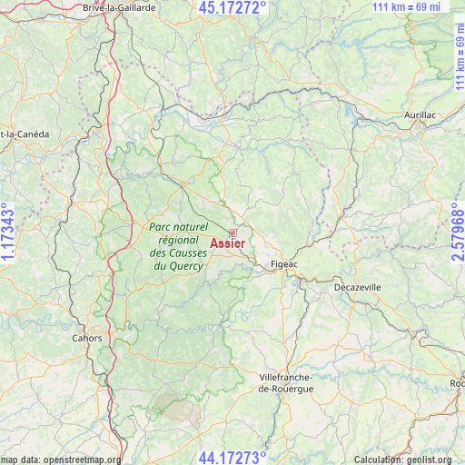
Assier GPS coordinates[2]
44° 40' 29.568" North, 1° 52' 35.58" East
| Map corner | latitude | longitude |
|---|---|---|
| Upper-left | 45.17272°, | 1.17343° |
| Center: | 44.67488°, | 1.87655° |
| Lower-right: | 44.17273°, | 2.57968° |
| Map W x H: | 111.2×111.2 km | = 69.1×69.1mi |
| max Lat: | 51.07786° ⇑82.3% North |
| Assier: | 44.67488° |
| min Lat: | ⇓17.7% South 41.3874° |
| min Long | Assier | max Long |
| -5.08615° | 1.87655° | 9.52242° |
| W 41.5%⇐ | ⇒58.5% E |
Elevation
Elevation of Assier is 353 m = 1158 ft, and this is 159.3 m = 523 ft above average elevation for this country.
| Max E: |
2333 m = 7654 ft | 14.5% |
| Assier | 353 m 1158 ft | |
| Avg. | 193.7 m = 635 ft | |
Min E: |
-1 m = -3 ft | 85.5% |
See also: France elevation on elevation.city.
Geographical zone
Assier is located in North temperate zone (between Tropic of Cancer and the Arctic Circle). Distance of this Northern Tropic circle is 2361.5 km =1467.4 mi to South.| Distance of | km | miles | from Assier |
|---|---|---|---|
| North Pole | 5039.7 | 3131.5 | to North |
| Arctic Circle | 2433.8 | 1512.3 | to North |
| Tropic Cancer | 2361.5 | 1467.4 | to South |
| Equator | 4967.4 | 3086.6 | to South |


Nearby cities:
15 places around Assier: (largest is in red/bold)
• Alvignac
22.2 km =13.8 mi,  319°
319°
• Aynac
12.3 km =7.6 mi,  350°
350°
• Béduer
11.8 km =7.3 mi,  151°
151°
• Cajarc
21.2 km =13.2 mi,  187°
187°
• Capdenac-Gare
19.6 km =12.2 mi,  124°
124°
• Cardaillac
9.6 km =6 mi,  87°
87°
• Faycelles
14.9 km =9.3 mi,  144°
144°
• Figeac
14.3 km =8.9 mi, 120°
• Gramat
17.1 km =10.6 mi,  313°
313°
• Lacapelle-Marival
7 km =4.3 mi,  32°
32°
• Latronquière
21.1 km =13.1 mi,  48°
48°
• Leyme
12.5 km =7.8 mi,  8°
8°
• Livernon
4.1 km =2.5 mi,  220°
220°
• Saint-Céré
20.3 km =12.6 mi,  3°
3°
• Saint-Laurent-les-Tours
22.5 km =14 mi, 3°
Sources, notices
• [Note1] Compared only with cities in France existing in our database
• [Src1] Map data: © OpenStreetMap contributors (CC-BY-SA)
• [Src2] Other city data from geonames.org with taken over terms of usage.
• [Src3] Geographical zone / Annual Mean Temperature by Robert A. Rohde @ Wikipedia
