Livernon geodata
Livernon (Occitanie) is a populated place; located in France in Europe/Paris (GMT+2) time zone. With population of 510 people, there are 15036 cities with bigger population in this country. Compared to other cities in France, 82.5% of cities are located further ↑North; 58.9% of cities are located further →East and 82.8% of cities have lower elevation than Livernon. Note1
Administrative division(s):
- Level 1: Occitanie
- Level 2: Lot
- Level 3: Arrondissement de Figeac
- Level 4: Livernon


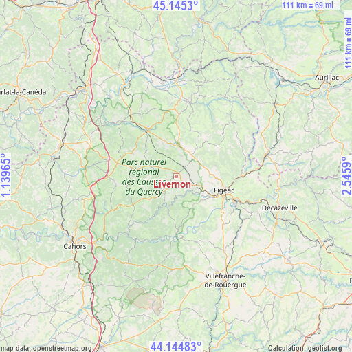
Livernon GPS coordinates[2]
44° 38' 49.992" North, 1° 50' 34.008" East
| Map corner | latitude | longitude |
|---|---|---|
| Upper-left | 45.1453°, | 1.13965° |
| Center: | 44.64722°, | 1.84278° |
| Lower-right: | 44.14483°, | 2.5459° |
| Map W x H: | 111.2×111.2 km | = 69.1×69.1mi |
| max Lat: | 51.07786° ⇑82.5% North |
| Livernon: | 44.64722° |
| min Lat: | ⇓17.5% South 41.3874° |
| min Long | Livernon | max Long |
| -5.08615° | 1.84278° | 9.52242° |
| W 41.1%⇐ | ⇒58.9% E |
Elevation
Elevation of Livernon is 320 m = 1050 ft, and this is 126.3 m = 414 ft above average elevation for this country.
| Max E: |
2333 m = 7654 ft | 17.2% |
| Livernon | 320 m 1050 ft | |
| Avg. | 193.7 m = 635 ft | |
Min E: |
-1 m = -3 ft | 82.8% |
See also: France elevation on elevation.city.
Geographical zone
Livernon is located in North temperate zone (between Tropic of Cancer and the Arctic Circle). Distance of this Northern Tropic circle is 2358.4 km =1465.4 mi to South.| Distance of | km | miles | from Livernon |
|---|---|---|---|
| North Pole | 5042.8 | 3133.4 | to North |
| Arctic Circle | 2436.9 | 1514.2 | to North |
| Tropic Cancer | 2358.4 | 1465.4 | to South |
| Equator | 4964.3 | 3084.7 | to South |


Nearby cities:
15 places around Livernon: (largest is in red/bold)
• Alvignac
23.2 km =14.4 mi,  329°
329°
• Assier
4.1 km =2.5 mi,  40°
40°
• Aynac
15.3 km =9.5 mi,  2°
2°
• Béduer
11 km =6.8 mi,  131°
131°
• Cajarc
18 km =11.2 mi,  180°
180°
• Capdenac-Gare
20.5 km =12.7 mi,  112°
112°
• Cardaillac
12.8 km =8 mi,  73°
73°
• Faycelles
14.6 km =9.1 mi, 128°
• Figeac
15.6 km =9.7 mi, 105°
• Gramat
17.8 km =11.1 mi, 326°
• Labastide-Murat
21.7 km =13.5 mi,  269°
269°
• Lacapelle-Marival
11 km =6.8 mi, 35°
• Leyme
16.1 km =10 mi,  16°
16°
• Montfaucon
22.7 km =14.1 mi,  281°
281°
• Saint-Céré
23.7 km =14.7 mi,  9°
9°
Sources, notices
• [Note1] Compared only with cities in France existing in our database
• [Src1] Map data: © OpenStreetMap contributors (CC-BY-SA)
• [Src2] Other city data from geonames.org with taken over terms of usage.
• [Src3] Geographical zone / Annual Mean Temperature by Robert A. Rohde @ Wikipedia
