Vendeuvre geodata
Vendeuvre (Normandy) is a populated place; located in France in Europe/Paris (GMT+2) time zone. With population of 763 people, there are 11026 cities with bigger population in this country. Compared to other cities in France, 79.5% of cities are located further ↓South; 78.7% of cities are located further →East and 88.6% of cities have higher elevation than Vendeuvre. Note1
Administrative division(s):
- Level 1: Normandy
- Level 2: Calvados
- Level 3: Arrondissement de Caen
- Level 4: Vendeuvre


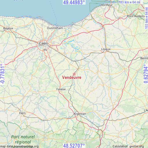
Vendeuvre GPS coordinates[2]
48° 59' 26.124" North, 0° 4' 30.684" West
| Map corner | latitude | longitude |
|---|---|---|
| Upper-left | 49.44983°, | -0.77831° |
| Center: | 48.99059°, | -0.07519° |
| Lower-right: | 48.52707°, | 0.62794° |
| Map W x H: | 102.6×102.6 km | = 63.8×63.8mi |
| max Lat: | 51.07786° ⇑20.5% North |
| Vendeuvre: | 48.99059° |
| min Lat: | ⇓79.5% South 41.3874° |
| min Long | Vendeuvre | max Long |
| -5.08615° | -0.07519° | 9.52242° |
| W 21.3%⇐ | ⇒78.7% E |
Elevation
Elevation of Vendeuvre is 33 m = 108 ft, and this is 160.7 m = 527 ft below average elevation for this country.
| Max E: |
2333 m = 7654 ft | 88.6% |
| Avg. | 193.7 m = 635 ft | |
| Vendeuvre | 33 m = 108 ft | |
Min E: |
-1 m = -3 ft | 11.4% |
See also: France elevation on elevation.city.
Geographical zone
Vendeuvre is located in North temperate zone (between Tropic of Cancer and the Arctic Circle). Distance of this North polar circle is 1953.9 km =1214.1 mi to North.| Distance of | km | miles | from Vendeuvre |
|---|---|---|---|
| North Pole | 4559.8 | 2833.3 | to North |
| Arctic Circle | 1953.9 | 1214.1 | to North |
| Tropic Cancer | 2841.3 | 1765.5 | to South |
| Equator | 5447.2 | 3384.7 | to South |


Nearby cities:
15 places around Vendeuvre: (largest is in red/bold)
• Airan
13.5 km =8.4 mi,  335°
335°
• Canon
9.3 km =5.8 mi,  352°
352°
• Falaise
14 km =8.7 mi,  218°
218°
• La Hoguette
14.2 km =8.8 mi,  206°
206°
• Le Mesnil-Mauger
12.3 km =7.6 mi,  32°
32°
• Magny-la-Campagne
6.8 km =4.2 mi, 342°
• Morteaux-Coulibœuf
6.4 km =4 mi,  174°
174°
• Notre-Dame-de-Fresnay
9.1 km =5.7 mi,  109°
109°
• Ouilly-le-Tesson
10.7 km =6.6 mi,  267°
267°
• Potigny
12.4 km =7.7 mi,  258°
258°
• Saint-Julien-le-Faucon
14.7 km =9.1 mi,  52°
52°
• Saint-Pierre-sur-Dives
4.2 km =2.6 mi, 46°
• Saint-Sylvain
12.7 km =7.9 mi,  305°
305°
• Soumont-Saint-Quentin
11.7 km =7.3 mi, 263°
• Villers-Canivet
14.3 km =8.9 mi,  247°
247°
Sources, notices
• [Note1] Compared only with cities in France existing in our database
• [Src1] Map data: © OpenStreetMap contributors (CC-BY-SA)
• [Src2] Other city data from geonames.org with taken over terms of usage.
• [Src3] Geographical zone / Annual Mean Temperature by Robert A. Rohde @ Wikipedia
