Morteaux-Coulibœuf geodata
Morteaux-Coulibœuf (Normandy) is a populated place; located in France in Europe/Paris (GMT+2) time zone. With population of 539 people, there are 14413 cities with bigger population in this country. Compared to other cities in France, 78.2% of cities are located further ↓South; 78.6% of cities are located further →East and 81.5% of cities have higher elevation than Morteaux-Coulibœuf. Note1
Administrative division(s):
- Level 1: Normandy
- Level 2: Calvados
- Level 3: Arrondissement de Caen
- Level 4: Morteaux-Coulibœuf


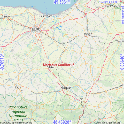
Morteaux-Coulibœuf GPS coordinates[2]
48° 55' 59.988" North, 0° 4' 0.012" West
| Map corner | latitude | longitude |
|---|---|---|
| Upper-left | 49.3931°, | -0.76979° |
| Center: | 48.93333°, | -0.06667° |
| Lower-right: | 48.46928°, | 0.63646° |
| Map W x H: | 102.7×102.7 km | = 63.8×63.8mi |
| max Lat: | 51.07786° ⇑21.8% North |
| Morteaux-Coulibœuf: | 48.93333° |
| min Lat: | ⇓78.2% South 41.3874° |
| min Long | Morteaux-Coulib | max Long |
| -5.08615° | -0.06667° | 9.52242° |
| W 21.4%⇐ | ⇒78.6% E |
Elevation
Elevation of Morteaux-Coulibœuf is 51 m = 167 ft, and this is 142.7 m = 468 ft below average elevation for this country.
| Max E: |
2333 m = 7654 ft | 81.5% |
| Avg. | 193.7 m = 635 ft | |
| Morteaux-Coulibœuf | 51 m = 167 ft | |
Min E: |
-1 m = -3 ft | 18.5% |
See also: France elevation on elevation.city.
Geographical zone
Morteaux-Coulibœuf is located in North temperate zone (between Tropic of Cancer and the Arctic Circle). Distance of this North polar circle is 1960.3 km =1218.1 mi to North.| Distance of | km | miles | from Morteaux-Coulibœuf |
|---|---|---|---|
| North Pole | 4566.2 | 2837.3 | to North |
| Arctic Circle | 1960.3 | 1218.1 | to North |
| Tropic Cancer | 2835 | 1761.6 | to South |
| Equator | 5440.9 | 3380.8 | to South |


Nearby cities:
15 places around Morteaux-Coulibœuf: (largest is in red/bold)
• Bailleul
15.5 km =9.6 mi,  162°
162°
• Canon
15.7 km =9.8 mi,  353°
353°
• Falaise
10.5 km =6.5 mi,  244°
244°
• La Hoguette
9.5 km =5.9 mi,  227°
227°
• Magny-la-Campagne
13.1 km =8.1 mi, 348°
• Notre-Dame-de-Fresnay
8.6 km =5.3 mi,  67°
67°
• Occagnes
17 km =10.6 mi,  181°
181°
• Ouilly-le-Tesson
12.7 km =7.9 mi,  297°
297°
• Potigny
13.4 km =8.3 mi,  287°
287°
• Saint-Pierre-sur-Dives
9.6 km =6 mi,  14°
14°
• Soumont-Saint-Quentin
13.2 km =8.2 mi, 292°
• Trun
12.4 km =7.7 mi,  144°
144°
• Ussy
15.9 km =9.9 mi,  276°
276°
• Vendeuvre
6.4 km =4 mi, 354°
• Villers-Canivet
13.8 km =8.6 mi,  273°
273°
Sources, notices
• [Note1] Compared only with cities in France existing in our database
• [Src1] Map data: © OpenStreetMap contributors (CC-BY-SA)
• [Src2] Other city data from geonames.org with taken over terms of usage.
• [Src3] Geographical zone / Annual Mean Temperature by Robert A. Rohde @ Wikipedia
