Eygurande geodata
Eygurande (Nouvelle-Aquitaine) is a populated place; located in France in Europe/Paris (GMT+2) time zone. With population of 798 people, there are 10635 cities with bigger population in this country. Compared to other cities in France, 71.6% of cities are located further ↑North; 50.2% of cities are located further →East and 97.1% of cities have lower elevation than Eygurande. Note1
Administrative division(s):
- Level 1: Nouvelle-Aquitaine
- Level 2: Département de la Corrèze
- Level 3: Ussel
- Level 4: Eygurande


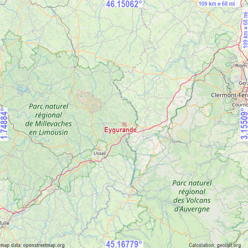
Eygurande GPS coordinates[2]
45° 39' 40.896" North, 2° 27' 7.056" East
| Map corner | latitude | longitude |
|---|---|---|
| Upper-left | 46.15062°, | 1.74884° |
| Center: | 45.66136°, | 2.45196° |
| Lower-right: | 45.16779°, | 3.15509° |
| Map W x H: | 109.3×109.3 km | = 67.9×67.9mi |
| max Lat: | 51.07786° ⇑71.6% North |
| Eygurande: | 45.66136° |
| min Lat: | ⇓28.4% South 41.3874° |
| min Long | Eygurande | max Long |
| -5.08615° | 2.45196° | 9.52242° |
| W 49.8%⇐ | ⇒50.2% E |
Elevation
Elevation of Eygurande is 733 m = 2405 ft, and this is 539.3 m = 1769 ft above average elevation for this country.
| Max E: |
2333 m = 7654 ft | 2.9% |
| Eygurande | 733 m 2405 ft | |
| Avg. | 193.7 m = 635 ft | |
Min E: |
-1 m = -3 ft | 97.1% |
See also: France elevation on elevation.city.
Geographical zone
Eygurande is located in North temperate zone (between Tropic of Cancer and the Arctic Circle). Distance of this North polar circle is 2324.1 km =1444.1 mi to North.| Distance of | km | miles | from Eygurande |
|---|---|---|---|
| North Pole | 4930 | 3063.4 | to North |
| Arctic Circle | 2324.1 | 1444.1 | to North |
| Tropic Cancer | 2471.1 | 1535.5 | to South |
| Equator | 5077.1 | 3154.8 | to South |


Nearby cities:
15 places around Eygurande: (largest is in red/bold)
• Bourg-Lastic
8.4 km =5.2 mi,  100°
100°
• Crocq
23.8 km =14.8 mi,  344°
344°
• Giat
15.7 km =9.8 mi,  4°
4°
• La Bourboule
23.8 km =14.8 mi,  109°
109°
• La Courtine
15.3 km =9.5 mi,  286°
286°
• La Feuillade
24.6 km =15.3 mi,  244°
244°
• La Tour-d’Auvergne
23.3 km =14.5 mi,  127°
127°
• Merlines
3.3 km =2.1 mi,  159°
159°
• Messeix
8.5 km =5.3 mi, 125°
• Saint-Angel
24.5 km =15.2 mi,  224°
224°
• Saint-Exupéry-les-Roches
17.4 km =10.8 mi,  201°
201°
• Saint-Sauves-d'Auvergne
19.2 km =11.9 mi, 110°
• Sornac
20.1 km =12.5 mi,  271°
271°
• Tauves
17.5 km =10.9 mi, 130°
• Ussel
16.8 km =10.4 mi, 221°
Sources, notices
• [Note1] Compared only with cities in France existing in our database
• [Src1] Map data: © OpenStreetMap contributors (CC-BY-SA)
• [Src2] Other city data from geonames.org with taken over terms of usage.
• [Src3] Geographical zone / Annual Mean Temperature by Robert A. Rohde @ Wikipedia
