La Bourboule geodata
La Bourboule (Auvergne-Rhône-Alpes) is a populated place; located in France in Europe/Paris (GMT+2) time zone. With population of 2,162 people, there are 4445 cities with bigger population in this country. Compared to other cities in France, 72.8% of cities are located further ↑North; 54.1% of cities are located further ←West and 98.3% of cities have lower elevation than La Bourboule. Note1
Administrative division(s):
- Level 1: Auvergne-Rhône-Alpes
- Level 2: Département du Puy-de-Dôme
- Level 3: Issoire
- Level 4: La Bourboule


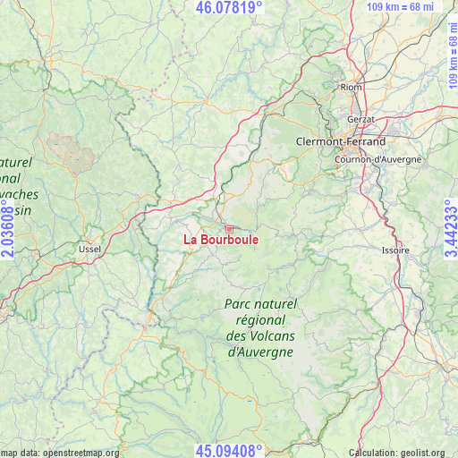
La Bourboule GPS coordinates[2]
45° 35' 17.844" North, 2° 44' 21.12" East
| Map corner | latitude | longitude |
|---|---|---|
| Upper-left | 46.07819°, | 2.03608° |
| Center: | 45.58829°, | 2.7392° |
| Lower-right: | 45.09408°, | 3.44233° |
| Map W x H: | 109.4×109.4 km | = 68×68mi |
| max Lat: | 51.07786° ⇑72.8% North |
| La Bourboule: | 45.58829° |
| min Lat: | ⇓27.2% South 41.3874° |
| min Long | La Bourboule | max Long |
| -5.08615° | 2.7392° | 9.52242° |
| W 54.1%⇐ | ⇒45.9% E |
Elevation
Elevation of La Bourboule is 855 m = 2805 ft, and this is 661.3 m = 2170 ft above average elevation for this country.
| Max E: |
2333 m = 7654 ft | 1.7% |
| La Bourboule | 855 m 2805 ft | |
| Avg. | 193.7 m = 635 ft | |
Min E: |
-1 m = -3 ft | 98.3% |
See also: France elevation on elevation.city.
Geographical zone
La Bourboule is located in North temperate zone (between Tropic of Cancer and the Arctic Circle). Distance of this North polar circle is 2332.2 km =1449.2 mi to North.| Distance of | km | miles | from La Bourboule |
|---|---|---|---|
| North Pole | 4938.1 | 3068.4 | to North |
| Arctic Circle | 2332.2 | 1449.2 | to North |
| Tropic Cancer | 2463 | 1530.4 | to South |
| Equator | 5068.9 | 3149.7 | to South |


Nearby cities:
15 places around La Bourboule: (largest is in red/bold)
• Aydat
19.9 km =12.4 mi,  66°
66°
• Besse-et-Saint-Anastaise
17.1 km =10.6 mi,  117°
117°
• Bourg-Lastic
15.5 km =9.6 mi,  295°
295°
• Gelles
20.2 km =12.6 mi,  5°
5°
• La Tour-d’Auvergne
7.2 km =4.5 mi,  212°
212°
• Le Cheix
20.8 km =12.9 mi,  103°
103°
• Messeix
15.7 km =9.8 mi,  281°
281°
• Mont-Dore
5.6 km =3.5 mi, 103°
• Murol
16 km =9.9 mi, 96°
• Nébouzat
19.1 km =11.9 mi,  42°
42°
• Olby
20.1 km =12.5 mi,  29°
29°
• Rochefort-Montagne
11.8 km =7.3 mi, 25°
• Saint-Nectaire
19.7 km =12.2 mi,  90°
90°
• Saint-Sauves-d'Auvergne
4.5 km =2.8 mi,  286°
286°
• Tauves
9.5 km =5.9 mi,  250°
250°
Sources, notices
• [Note1] Compared only with cities in France existing in our database
• [Src1] Map data: © OpenStreetMap contributors (CC-BY-SA)
• [Src2] Other city data from geonames.org with taken over terms of usage.
• [Src3] Geographical zone / Annual Mean Temperature by Robert A. Rohde @ Wikipedia
