Évry geodata
Évry (Île-de-France) is a seat of a second-order administrative division; located in France in Europe/Paris (GMT+2) time zone. With population of 51,900 people, there are 118 cities with bigger population in this country. Compared to other cities in France, 71.6% of cities are located further ↓South; 50.4% of cities are located further →East and 70.5% of cities have higher elevation than Évry. Note1
Administrative division(s):
- Level 1: Île-de-France
- Level 2: Département de l'Essonne
- Level 3: Arrondissement d'Évry
- Level 4: Évry-Courcouronnes


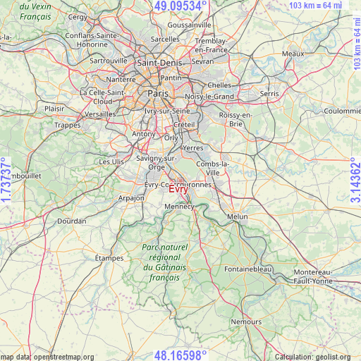
Évry GPS coordinates[2]
48° 37' 58.08" North, 2° 26' 25.764" East
| Map corner | latitude | longitude |
|---|---|---|
| Upper-left | 49.09534°, | 1.73737° |
| Center: | 48.6328°, | 2.44049° |
| Lower-right: | 48.16598°, | 3.14362° |
| Map W x H: | 103.3×103.3 km | = 64.2×64.2mi |
| max Lat: | 51.07786° ⇑28.4% North |
| Évry: | 48.6328° |
| min Lat: | ⇓71.6% South 41.3874° |
| min Long | Évry | max Long |
| -5.08615° | 2.44049° | 9.52242° |
| W 49.6%⇐ | ⇒50.4% E |
Elevation
Elevation of Évry is 77 m = 253 ft, and this is 116.7 m = 383 ft below average elevation for this country.
| Max E: |
2333 m = 7654 ft | 70.5% |
| Avg. | 193.7 m = 635 ft | |
| Évry | 77 m = 253 ft | |
Min E: |
-1 m = -3 ft | 29.5% |
See also: Évry elevation on elevation.city.
Geographical zone
Évry is located in North temperate zone (between Tropic of Cancer and the Arctic Circle). Distance of this North polar circle is 1993.7 km =1238.8 mi to North.| Distance of | km | miles | from Évry |
|---|---|---|---|
| North Pole | 4599.6 | 2858.1 | to North |
| Arctic Circle | 1993.7 | 1238.8 | to North |
| Tropic Cancer | 2801.5 | 1740.8 | to South |
| Equator | 5407.5 | 3360.1 | to South |


Nearby cities:
15 places around Évry: (largest is in red/bold)
• Bondoufle
5.1 km =3.2 mi,  244°
244°
• Corbeil-Essonnes
4.6 km =2.9 mi,  130°
130°
• Courcouronnes
3.2 km =2 mi,  229°
229°
• Fleury-Mérogis
5.7 km =3.5 mi,  275°
275°
• Grigny
4.2 km =2.6 mi,  304°
304°
• Lisses
3.6 km =2.2 mi,  201°
201°
• Ris-Orangis
2.8 km =1.7 mi,  316°
316°
• Saint-Germain-lès-Corbeil
3.7 km =2.3 mi,  108°
108°
• Saint-Pierre-du-Perray
4.7 km =2.9 mi,  121°
121°
• Saintry-sur-Seine
5.7 km =3.5 mi,  135°
135°
• Soisy-sur-Seine
2 km =1.2 mi,  25°
25°
• Tigery
5.1 km =3.2 mi,  77°
77°
• Villabé
4.9 km =3 mi,  170°
170°
• Viry-Châtillon
5.6 km =3.5 mi, 321°
• Étiolles
3.1 km =1.9 mi,  90°
90°
Sources, notices
• [Note1] Compared only with cities in France existing in our database
• [Src1] Map data: © OpenStreetMap contributors (CC-BY-SA)
• [Src2] Other city data from geonames.org with taken over terms of usage.
• [Src3] Geographical zone / Annual Mean Temperature by Robert A. Rohde @ Wikipedia
