Ebersheim geodata
Ebersheim (Grand Est) is a populated place; located in France in Europe/Paris (GMT+2) time zone. With population of 1,968 people, there are 4860 cities with bigger population in this country. Compared to other cities in France, 64.6% of cities are located further ↓South; 98% of cities are located further ←West and 58.7% of cities have lower elevation than Ebersheim. Note1
Administrative division(s):
- Level 1: Grand Est
- Level 2: Bas-Rhin
- Level 3: Arrondissement de Sélestat-Erstein
- Level 4: Ebersheim


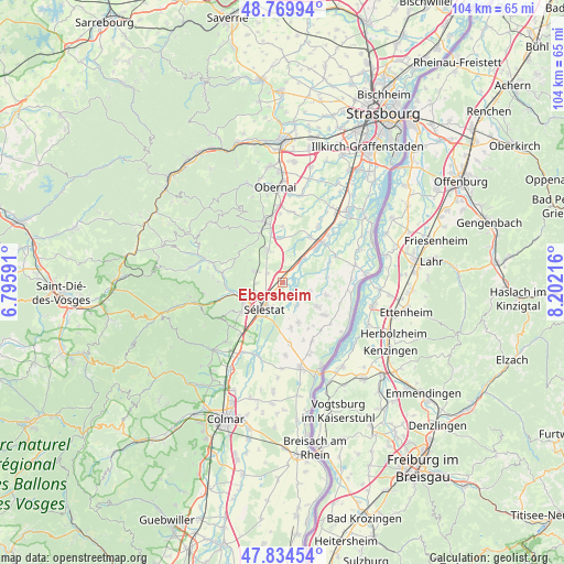
Ebersheim GPS coordinates[2]
48° 18' 15.768" North, 7° 29' 56.508" East
| Map corner | latitude | longitude |
|---|---|---|
| Upper-left | 48.76994°, | 6.79591° |
| Center: | 48.30438°, | 7.49903° |
| Lower-right: | 47.83454°, | 8.20216° |
| Map W x H: | 104×104 km | = 64.6×64.6mi |
| max Lat: | 51.07786° ⇑35.4% North |
| Ebersheim: | 48.30438° |
| min Lat: | ⇓64.6% South 41.3874° |
| min Long | Ebersheim | max Long |
| -5.08615° | 7.49903° | 9.52242° |
| W 98%⇐ | ⇒2% E |
Elevation
Elevation of Ebersheim is 164 m = 538 ft, and this is 29.7 m = 97 ft below average elevation for this country.
| Max E: |
2333 m = 7654 ft | 41.3% |
| Avg. | 193.7 m = 635 ft | |
| Ebersheim | 164 m = 538 ft | |
Min E: |
-1 m = -3 ft | 58.7% |
See also: France elevation on elevation.city.
Geographical zone
Ebersheim is located in North temperate zone (between Tropic of Cancer and the Arctic Circle). Distance of this North polar circle is 2030.2 km =1261.5 mi to North.| Distance of | km | miles | from Ebersheim |
|---|---|---|---|
| North Pole | 4636.1 | 2880.7 | to North |
| Arctic Circle | 2030.2 | 1261.5 | to North |
| Tropic Cancer | 2765 | 1718.1 | to South |
| Equator | 5370.9 | 3337.3 | to South |


Nearby cities:
15 places around Ebersheim: (largest is in red/bold)
• Baldenheim
8 km =5 mi,  157°
157°
• Bindernheim
8.4 km =5.2 mi,  106°
106°
• Châtenois
8.1 km =5 mi,  243°
243°
• Dambach-la-Ville
5.9 km =3.7 mi,  291°
291°
• Ebersmunster
2.1 km =1.3 mi,  68°
68°
• Epfig
6.6 km =4.1 mi,  337°
337°
• Hilsenheim
5.1 km =3.2 mi, 111°
• Huttenheim
8.4 km =5.2 mi,  44°
44°
• Kogenheim
4.9 km =3 mi, 41°
• Muttersholtz
4.9 km =3 mi,  146°
146°
• Scherwiller
6.1 km =3.8 mi,  251°
251°
• Sermersheim
6.1 km =3.8 mi, 40°
• Stotzheim
8.3 km =5.2 mi,  356°
356°
• Sélestat
6 km =3.7 mi,  218°
218°
• Wittisheim
7.9 km =4.9 mi,  124°
124°
Sources, notices
• [Note1] Compared only with cities in France existing in our database
• [Src1] Map data: © OpenStreetMap contributors (CC-BY-SA)
• [Src2] Other city data from geonames.org with taken over terms of usage.
• [Src3] Geographical zone / Annual Mean Temperature by Robert A. Rohde @ Wikipedia
