Bédoin geodata
Bédoin (Provence-Alpes-Côte d'Azur) is a populated place; located in France in Europe/Paris (GMT+2) time zone. With population of 3,016 people, there are 3232 cities with bigger population in this country. Compared to other cities in France, 86% of cities are located further ↑North; 79.6% of cities are located further ←West and 82.5% of cities have lower elevation than Bédoin. Note1
Administrative division(s):
- Level 1: Provence-Alpes-Côte d'Azur
- Level 2: Département du Vaucluse
- Level 3: Arrondissement de Carpentras
- Level 4: Bédoin


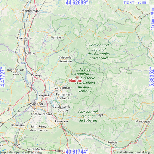
Bédoin GPS coordinates[2]
44° 7' 27.552" North, 5° 10' 49.44" East
| Map corner | latitude | longitude |
|---|---|---|
| Upper-left | 44.62689°, | 4.47727° |
| Center: | 44.12432°, | 5.1804° |
| Lower-right: | 43.61744°, | 5.88352° |
| Map W x H: | 112.2×112.2 km | = 69.7×69.7mi |
| max Lat: | 51.07786° ⇑86% North |
| Bédoin: | 44.12432° |
| min Lat: | ⇓14% South 41.3874° |
| min Long | Bédoin | max Long |
| -5.08615° | 5.1804° | 9.52242° |
| W 79.6%⇐ | ⇒20.4% E |
Elevation
Elevation of Bédoin is 316 m = 1037 ft, and this is 122.3 m = 401 ft above average elevation for this country.
| Max E: |
2333 m = 7654 ft | 17.5% |
| Bédoin | 316 m 1037 ft | |
| Avg. | 193.7 m = 635 ft | |
Min E: |
-1 m = -3 ft | 82.5% |
See also: France elevation on elevation.city.
Geographical zone
Bédoin is located in North temperate zone (between Tropic of Cancer and the Arctic Circle). Distance of this Northern Tropic circle is 2300.2 km =1429.3 mi to South.| Distance of | km | miles | from Bédoin |
|---|---|---|---|
| North Pole | 5100.9 | 3169.6 | to North |
| Arctic Circle | 2495 | 1550.3 | to North |
| Tropic Cancer | 2300.2 | 1429.3 | to South |
| Equator | 4906.2 | 3048.6 | to South |


Nearby cities:
15 places around Bédoin: (largest is in red/bold)
• Aubignan
12.7 km =7.9 mi,  257°
257°
• Beaumes-de-Venise
12 km =7.5 mi,  268°
268°
• Caromb
6 km =3.7 mi, 255°
• Carpentras
13.1 km =8.1 mi,  233°
233°
• Entrechaux
10.9 km =6.8 mi,  341°
341°
• Gigondas
14.7 km =9.1 mi,  287°
287°
• Le Barroux
6.6 km =4.1 mi,  281°
281°
• Malaucène
6.7 km =4.2 mi,  325°
325°
• Malemort-du-Comtat
11.6 km =7.2 mi,  188°
188°
• Mazan
8.6 km =5.3 mi,  209°
209°
• Mollans-sur-Ouvèze
12.5 km =7.8 mi,  3°
3°
• Mormoiron
6.3 km =3.9 mi,  178°
178°
• Saint-Didier
14.5 km =9 mi,  202°
202°
• Venasque
14.5 km =9 mi, 190°
• Villes-sur-Auzon
8.7 km =5.4 mi,  150°
150°
Sources, notices
• [Note1] Compared only with cities in France existing in our database
• [Src1] Map data: © OpenStreetMap contributors (CC-BY-SA)
• [Src2] Other city data from geonames.org with taken over terms of usage.
• [Src3] Geographical zone / Annual Mean Temperature by Robert A. Rohde @ Wikipedia
