Malaucène geodata
Malaucène (Provence-Alpes-Côte d'Azur) is a populated place; located in France in Europe/Paris (GMT+2) time zone. With population of 2,721 people, there are 3598 cities with bigger population in this country. Compared to other cities in France, 85.7% of cities are located further ↑North; 79% of cities are located further ←West and 86.4% of cities have lower elevation than Malaucène. Note1
Administrative division(s):
- Level 1: Provence-Alpes-Côte d'Azur
- Level 2: Département du Vaucluse
- Level 3: Arrondissement de Carpentras
- Level 4: Malaucène


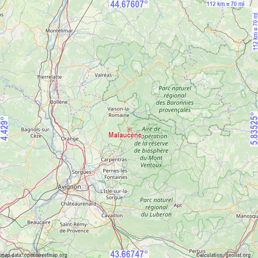
Malaucène GPS coordinates[2]
44° 10' 26.148" North, 5° 7' 55.668" East
| Map corner | latitude | longitude |
|---|---|---|
| Upper-left | 44.67607°, | 4.429° |
| Center: | 44.17393°, | 5.13213° |
| Lower-right: | 43.66747°, | 5.83525° |
| Map W x H: | 112.1×112.1 km | = 69.7×69.7mi |
| max Lat: | 51.07786° ⇑85.7% North |
| Malaucène: | 44.17393° |
| min Lat: | ⇓14.3% South 41.3874° |
| min Long | Malaucène | max Long |
| -5.08615° | 5.13213° | 9.52242° |
| W 79%⇐ | ⇒21% E |
Elevation
Elevation of Malaucène is 365 m = 1198 ft, and this is 171.3 m = 562 ft above average elevation for this country.
| Max E: |
2333 m = 7654 ft | 13.6% |
| Malaucène | 365 m 1198 ft | |
| Avg. | 193.7 m = 635 ft | |
Min E: |
-1 m = -3 ft | 86.4% |
See also: France elevation on elevation.city.
Geographical zone
Malaucène is located in North temperate zone (between Tropic of Cancer and the Arctic Circle). Distance of this Northern Tropic circle is 2305.8 km =1432.8 mi to South.| Distance of | km | miles | from Malaucène |
|---|---|---|---|
| North Pole | 5095.4 | 3166.1 | to North |
| Arctic Circle | 2489.5 | 1546.9 | to North |
| Tropic Cancer | 2305.8 | 1432.8 | to South |
| Equator | 4911.7 | 3052 | to South |


Nearby cities:
15 places around Malaucène: (largest is in red/bold)
• Aubignan
11.9 km =7.4 mi,  225°
225°
• Beaumes-de-Venise
9.9 km =6.2 mi, 234°
• Bédoin
6.7 km =4.2 mi,  145°
145°
• Caromb
7.3 km =4.5 mi,  195°
195°
• Entrechaux
4.9 km =3 mi,  5°
5°
• Gigondas
10.2 km =6.3 mi,  263°
263°
• Le Barroux
4.9 km =3 mi,  211°
211°
• Mollans-sur-Ouvèze
8.3 km =5.2 mi,  33°
33°
• Mormoiron
12.5 km =7.8 mi,  160°
160°
• Puyméras
10.7 km =6.6 mi,  358°
358°
• Roaix
12.2 km =7.6 mi,  310°
310°
• Sablet
10.3 km =6.4 mi,  281°
281°
• Saint-Romain-en-Viennois
9.5 km =5.9 mi,  349°
349°
• Séguret
9.4 km =5.8 mi,  292°
292°
• Vaison-la-Romaine
8.6 km =5.3 mi,  327°
327°
Sources, notices
• [Note1] Compared only with cities in France existing in our database
• [Src1] Map data: © OpenStreetMap contributors (CC-BY-SA)
• [Src2] Other city data from geonames.org with taken over terms of usage.
• [Src3] Geographical zone / Annual Mean Temperature by Robert A. Rohde @ Wikipedia
