Cappelle-en-Pévèle geodata
Cappelle-en-Pévèle (Hauts-de-France) is a populated place; located in France in Europe/Paris (GMT+2) time zone. With population of 1,997 people, there are 4795 cities with bigger population in this country. Compared to other cities in France, 97.4% of cities are located further ↓South; 60.2% of cities are located further ←West and 84.1% of cities have higher elevation than Cappelle-en-Pévèle. Note1
Administrative division(s):
- Level 1: Hauts-de-France
- Level 2: Nord
- Level 3: Arrondissement de Lille
- Level 4: Cappelle-en-Pévèle


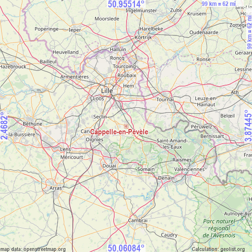
Cappelle-en-Pévèle GPS coordinates[2]
50° 30' 36.396" North, 3° 10' 16.788" East
| Map corner | latitude | longitude |
|---|---|---|
| Upper-left | 50.95514°, | 2.4682° |
| Center: | 50.51011°, | 3.17133° |
| Lower-right: | 50.06084°, | 3.87445° |
| Map W x H: | 99.4×99.4 km | = 61.8×61.8mi |
| max Lat: | 51.07786° ⇑2.6% North |
| Cappelle-en-Pévèle: | 50.51011° |
| min Lat: | ⇓97.4% South 41.3874° |
| min Long | Cappelle-en-Pé | max Long |
| -5.08615° | 3.17133° | 9.52242° |
| W 60.2%⇐ | ⇒39.8% E |
Elevation
Elevation of Cappelle-en-Pévèle is 44 m = 144 ft, and this is 149.7 m = 491 ft below average elevation for this country.
| Max E: |
2333 m = 7654 ft | 84.1% |
| Avg. | 193.7 m = 635 ft | |
| Cappelle-en-Pévèle | 44 m = 144 ft | |
Min E: |
-1 m = -3 ft | 15.9% |
See also: France elevation on elevation.city.
Geographical zone
Cappelle-en-Pévèle is located in North temperate zone (between Tropic of Cancer and the Arctic Circle). Distance of this North polar circle is 1785 km =1109.1 mi to North.| Distance of | km | miles | from Cappelle-en-Pévèle |
|---|---|---|---|
| North Pole | 4390.9 | 2728.4 | to North |
| Arctic Circle | 1785 | 1109.1 | to North |
| Tropic Cancer | 3010.3 | 1870.5 | to South |
| Equator | 5616.2 | 3489.7 | to South |


Nearby cities:
15 places around Cappelle-en-Pévèle: (largest is in red/bold)
• Bersée
3.8 km =2.4 mi,  206°
206°
• Cobrieux
5.4 km =3.4 mi,  48°
48°
• Ennevelin
4.5 km =2.8 mi,  319°
319°
• Faumont
6.1 km =3.8 mi,  203°
203°
• Fretin
5.8 km =3.6 mi,  335°
335°
• Genech
4 km =2.5 mi, 53°
• Louvil
5.5 km =3.4 mi,  16°
16°
• Mons-en-Pévèle
6.2 km =3.9 mi,  236°
236°
• Mérignies
4.3 km =2.7 mi,  264°
264°
• Nomain
5.7 km =3.5 mi,  103°
103°
• Orchies
6.5 km =4 mi,  137°
137°
• Pont-à-Marcq
4.2 km =2.6 mi,  288°
288°
• Péronne-en-Mélantois
6.4 km =4 mi,  358°
358°
• Templeuve-en-Pévèle
1.5 km =0.9 mi, 17°
• Tourmignies
6.2 km =3.9 mi,  267°
267°
Sources, notices
• [Note1] Compared only with cities in France existing in our database
• [Src1] Map data: © OpenStreetMap contributors (CC-BY-SA)
• [Src2] Other city data from geonames.org with taken over terms of usage.
• [Src3] Geographical zone / Annual Mean Temperature by Robert A. Rohde @ Wikipedia
