Elnes geodata
Elnes (Hauts-de-France) is a populated place; located in France in Europe/Paris (GMT+2) time zone. With population of 737 people, there are 11325 cities with bigger population in this country. Compared to other cities in France, 98.7% of cities are located further ↓South; 55.4% of cities are located further →East and 81.1% of cities have higher elevation than Elnes. Note1
Administrative division(s):
- Level 1: Hauts-de-France
- Level 2: Pas-de-Calais
- Level 3: Arrondissement de Saint-Omer
- Level 4: Elnes


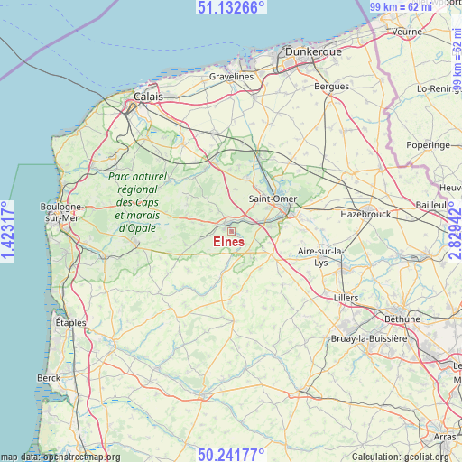
Elnes GPS coordinates[2]
50° 41' 21.588" North, 2° 7' 34.68" East
| Map corner | latitude | longitude |
|---|---|---|
| Upper-left | 51.13266°, | 1.42317° |
| Center: | 50.68933°, | 2.1263° |
| Lower-right: | 50.24177°, | 2.82942° |
| Map W x H: | 99.1×99.1 km | = 61.6×61.6mi |
| max Lat: | 51.07786° ⇑1.3% North |
| Elnes: | 50.68933° |
| min Lat: | ⇓98.7% South 41.3874° |
| min Long | Elnes | max Long |
| -5.08615° | 2.1263° | 9.52242° |
| W 44.6%⇐ | ⇒55.4% E |
Elevation
Elevation of Elnes is 52 m = 171 ft, and this is 141.7 m = 465 ft below average elevation for this country.
| Max E: |
2333 m = 7654 ft | 81.1% |
| Avg. | 193.7 m = 635 ft | |
| Elnes | 52 m = 171 ft | |
Min E: |
-1 m = -3 ft | 18.9% |
See also: France elevation on elevation.city.
Geographical zone
Elnes is located in North temperate zone (between Tropic of Cancer and the Arctic Circle). Distance of this North polar circle is 1765 km =1096.7 mi to North.| Distance of | km | miles | from Elnes |
|---|---|---|---|
| North Pole | 4370.9 | 2716 | to North |
| Arctic Circle | 1765 | 1096.7 | to North |
| Tropic Cancer | 3030.2 | 1882.9 | to South |
| Equator | 5636.1 | 3502.1 | to South |


Nearby cities:
15 places around Elnes: (largest is in red/bold)
• Acquin-Westbécourt
5 km =3.1 mi,  328°
328°
• Avroult
6.4 km =4 mi,  166°
166°
• Cléty
5.8 km =3.6 mi,  133°
133°
• Dohem
7 km =4.3 mi,  143°
143°
• Esquerdes
4.7 km =2.9 mi,  69°
69°
• Hallines
7.4 km =4.6 mi, 71°
• Lumbres
2 km =1.2 mi,  348°
348°
• Merck-Saint-Liévin
7.2 km =4.5 mi,  185°
185°
• Nielles-lès-Bléquin
6.9 km =4.3 mi,  255°
255°
• Ouve-Wirquin
4.7 km =2.9 mi, 170°
• Pihem
6.2 km =3.9 mi,  96°
96°
• Seninghem
6.8 km =4.2 mi,  282°
282°
• Setques
3.4 km =2.1 mi,  42°
42°
• Wismes
5.5 km =3.4 mi,  224°
224°
• Zudausques
6.8 km =4.2 mi,  12°
12°
Sources, notices
• [Note1] Compared only with cities in France existing in our database
• [Src1] Map data: © OpenStreetMap contributors (CC-BY-SA)
• [Src2] Other city data from geonames.org with taken over terms of usage.
• [Src3] Geographical zone / Annual Mean Temperature by Robert A. Rohde @ Wikipedia
