Seninghem geodata
Seninghem (Hauts-de-France) is a populated place; located in France in Europe/Paris (GMT+2) time zone. With population of 550 people, there are 14213 cities with bigger population in this country. Compared to other cities in France, 98.8% of cities are located further ↓South; 56.7% of cities are located further →East and 61.5% of cities have higher elevation than Seninghem. Note1
Administrative division(s):
- Level 1: Hauts-de-France
- Level 2: Pas-de-Calais
- Level 3: Arrondissement de Saint-Omer
- Level 4: Seninghem


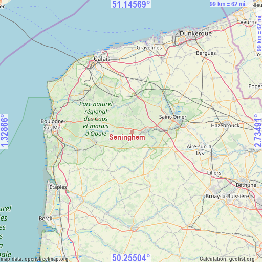
Seninghem GPS coordinates[2]
50° 42' 8.928" North, 2° 1' 54.408" East
| Map corner | latitude | longitude |
|---|---|---|
| Upper-left | 51.14569°, | 1.32866° |
| Center: | 50.70248°, | 2.03178° |
| Lower-right: | 50.25504°, | 2.73491° |
| Map W x H: | 99×99 km | = 61.5×61.5mi |
| max Lat: | 51.07786° ⇑1.2% North |
| Seninghem: | 50.70248° |
| min Lat: | ⇓98.8% South 41.3874° |
| min Long | Seninghem | max Long |
| -5.08615° | 2.03178° | 9.52242° |
| W 43.3%⇐ | ⇒56.7% E |
Elevation
Elevation of Seninghem is 98 m = 322 ft, and this is 95.7 m = 314 ft below average elevation for this country.
| Max E: |
2333 m = 7654 ft | 61.5% |
| Avg. | 193.7 m = 635 ft | |
| Seninghem | 98 m = 322 ft | |
Min E: |
-1 m = -3 ft | 38.5% |
See also: France elevation on elevation.city.
Geographical zone
Seninghem is located in North temperate zone (between Tropic of Cancer and the Arctic Circle). Distance of this North polar circle is 1763.6 km =1095.8 mi to North.| Distance of | km | miles | from Seninghem |
|---|---|---|---|
| North Pole | 4369.5 | 2715.1 | to North |
| Arctic Circle | 1763.6 | 1095.8 | to North |
| Tropic Cancer | 3031.7 | 1883.8 | to South |
| Equator | 5637.6 | 3503 | to South |


Nearby cities:
15 places around Seninghem: (largest is in red/bold)
• Acquin-Westbécourt
5 km =3.1 mi,  55°
55°
• Alquines
5.1 km =3.2 mi,  327°
327°
• Bonningues-lès-Ardres
10.1 km =6.3 mi,  353°
353°
• Campagne-lès-Boulonnais
10.3 km =6.4 mi,  194°
194°
• Elnes
6.8 km =4.2 mi,  102°
102°
• Lumbres
6.3 km =3.9 mi,  85°
85°
• Mentque-Nortbécourt
9.8 km =6.1 mi,  22°
22°
• Merck-Saint-Liévin
10.5 km =6.5 mi,  145°
145°
• Nielles-lès-Bléquin
3.1 km =1.9 mi,  180°
180°
• Ouve-Wirquin
9.6 km =6 mi,  129°
129°
• Quesques
6.9 km =4.3 mi,  271°
271°
• Setques
9 km =5.6 mi,  83°
83°
• Thiembronne
9.3 km =5.8 mi,  168°
168°
• Wismes
6 km =3.7 mi, 152°
• Zudausques
9.6 km =6 mi, 57°
Sources, notices
• [Note1] Compared only with cities in France existing in our database
• [Src1] Map data: © OpenStreetMap contributors (CC-BY-SA)
• [Src2] Other city data from geonames.org with taken over terms of usage.
• [Src3] Geographical zone / Annual Mean Temperature by Robert A. Rohde @ Wikipedia
