Écuras geodata
Écuras (Nouvelle-Aquitaine) is a populated place; located in France in Europe/Paris (GMT+2) time zone. With population of 641 people, there are 12662 cities with bigger population in this country. Compared to other cities in France, 71.2% of cities are located further ↑North; 72.7% of cities are located further →East and 71% of cities have lower elevation than Écuras. Note1
Administrative division(s):
- Level 1: Nouvelle-Aquitaine
- Level 2: Charente
- Level 3: Arrondissement d’Angoulême
- Level 4: Écuras


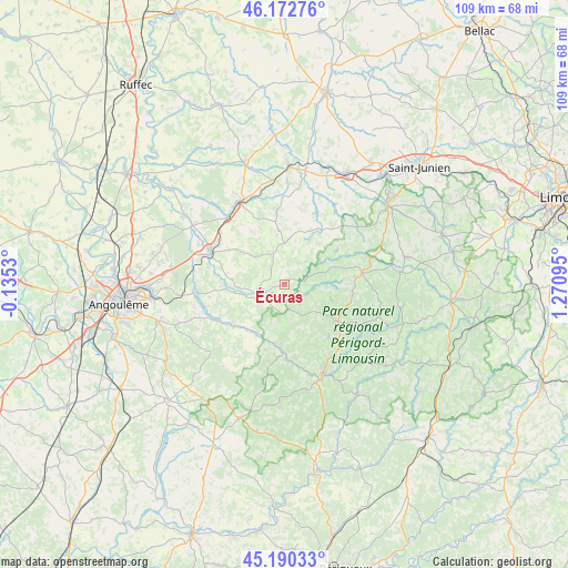
Écuras GPS coordinates[2]
45° 41' 1.32" North, 0° 34' 4.188" East
| Map corner | latitude | longitude |
|---|---|---|
| Upper-left | 46.17276°, | -0.1353° |
| Center: | 45.6837°, | 0.56783° |
| Lower-right: | 45.19033°, | 1.27095° |
| Map W x H: | 109.2×109.2 km | = 67.9×67.9mi |
| max Lat: | 51.07786° ⇑71.2% North |
| Écuras: | 45.6837° |
| min Lat: | ⇓28.8% South 41.3874° |
| min Long | Écuras | max Long |
| -5.08615° | 0.56783° | 9.52242° |
| W 27.3%⇐ | ⇒72.7% E |
Elevation
Elevation of Écuras is 224 m = 735 ft, and this is 30.3 m = 99 ft above average elevation for this country.
| Max E: |
2333 m = 7654 ft | 29% |
| Écuras | 224 m 735 ft | |
| Avg. | 193.7 m = 635 ft | |
Min E: |
-1 m = -3 ft | 71% |
See also: France elevation on elevation.city.
Geographical zone
Écuras is located in North temperate zone (between Tropic of Cancer and the Arctic Circle). Distance of this North polar circle is 2321.6 km =1442.6 mi to North.| Distance of | km | miles | from Écuras |
|---|---|---|---|
| North Pole | 4927.5 | 3061.8 | to North |
| Arctic Circle | 2321.6 | 1442.6 | to North |
| Tropic Cancer | 2473.6 | 1537 | to South |
| Equator | 5079.6 | 3156.3 | to South |


Nearby cities:
15 places around Écuras: (largest is in red/bold)
• Augignac
14.6 km =9.1 mi,  135°
135°
• Busserolles
5.8 km =3.6 mi,  97°
97°
• Bussière-Badil
4.6 km =2.9 mi, 141°
• Champniers-et-Reilhac
13 km =8.1 mi, 98°
• Javerlhac-et-la-Chapelle-Saint-Robert
12.7 km =7.9 mi,  182°
182°
• La Rochefoucauld
15.5 km =9.6 mi,  294°
294°
• Marillac-le-Franc
11.8 km =7.3 mi,  297°
297°
• Marthon
12.4 km =7.7 mi,  231°
231°
• Montbron
5.6 km =3.5 mi,  250°
250°
• Montembœuf
10.5 km =6.5 mi,  353°
353°
• Piégut-Pluviers
11.7 km =7.3 mi,  125°
125°
• Saint-Estèphe
12.6 km =7.8 mi, 143°
• Saint-Mathieu
15 km =9.3 mi,  80°
80°
• Saint-Sornin
10.2 km =6.3 mi,  275°
275°
• Vitrac-Saint-Vincent
13.7 km =8.5 mi,  335°
335°
Sources, notices
• [Note1] Compared only with cities in France existing in our database
• [Src1] Map data: © OpenStreetMap contributors (CC-BY-SA)
• [Src2] Other city data from geonames.org with taken over terms of usage.
• [Src3] Geographical zone / Annual Mean Temperature by Robert A. Rohde @ Wikipedia
