Busserolles geodata
Busserolles (Nouvelle-Aquitaine) is a populated place; located in France in Europe/Paris (GMT+2) time zone. With population of 547 people, there are 14264 cities with bigger population in this country. Compared to other cities in France, 71.3% of cities are located further ↑North; 72% of cities are located further →East and 58.9% of cities have lower elevation than Busserolles. Note1
Administrative division(s):
- Level 1: Nouvelle-Aquitaine
- Level 2: Dordogne
- Level 3: Arrondissement de Nontron
- Level 4: Busserolles


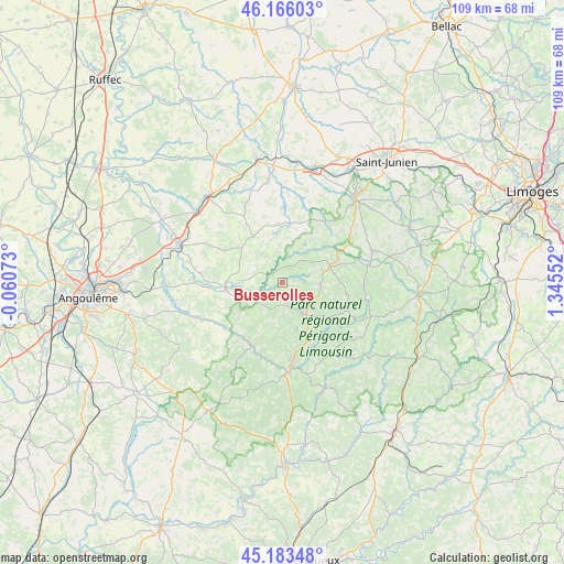
Busserolles GPS coordinates[2]
45° 40' 36.876" North, 0° 38' 32.604" East
| Map corner | latitude | longitude |
|---|---|---|
| Upper-left | 46.16603°, | -0.06073° |
| Center: | 45.67691°, | 0.64239° |
| Lower-right: | 45.18348°, | 1.34552° |
| Map W x H: | 109.2×109.2 km | = 67.9×67.9mi |
| max Lat: | 51.07786° ⇑71.3% North |
| Busserolles: | 45.67691° |
| min Lat: | ⇓28.7% South 41.3874° |
| min Long | Busserolles | max Long |
| -5.08615° | 0.64239° | 9.52242° |
| W 28%⇐ | ⇒72% E |
Elevation
Elevation of Busserolles is 165 m = 541 ft, and this is 28.7 m = 94 ft below average elevation for this country.
| Max E: |
2333 m = 7654 ft | 41.1% |
| Avg. | 193.7 m = 635 ft | |
| Busserolles | 165 m = 541 ft | |
Min E: |
-1 m = -3 ft | 58.9% |
See also: France elevation on elevation.city.
Geographical zone
Busserolles is located in North temperate zone (between Tropic of Cancer and the Arctic Circle). Distance of this North polar circle is 2322.4 km =1443.1 mi to North.| Distance of | km | miles | from Busserolles |
|---|---|---|---|
| North Pole | 4928.3 | 3062.3 | to North |
| Arctic Circle | 2322.4 | 1443.1 | to North |
| Tropic Cancer | 2472.9 | 1536.6 | to South |
| Equator | 5078.8 | 3155.8 | to South |


Nearby cities:
15 places around Busserolles: (largest is in red/bold)
• Abjat-sur-Bandiat
13.6 km =8.5 mi,  138°
138°
• Augignac
10.7 km =6.6 mi,  155°
155°
• Bussière-Badil
4.1 km =2.5 mi,  226°
226°
• Champniers-et-Reilhac
7.2 km =4.5 mi,  99°
99°
• Cussac
16.4 km =10.2 mi,  78°
78°
• Javerlhac-et-la-Chapelle-Saint-Robert
13.5 km =8.4 mi,  208°
208°
• Marval
13.3 km =8.3 mi,  114°
114°
• Montbron
11.1 km =6.9 mi,  264°
264°
• Montembœuf
13.2 km =8.2 mi,  328°
328°
• Piégut-Pluviers
7.1 km =4.4 mi,  148°
148°
• Saint-Estèphe
9.5 km =5.9 mi,  170°
170°
• Saint-Mathieu
9.6 km =6 mi,  70°
70°
• Saint-Sornin
16.1 km =10 mi,  276°
276°
• Vayres
15.9 km =9.9 mi,  54°
54°
• Écuras
5.8 km =3.6 mi, 277°
Sources, notices
• [Note1] Compared only with cities in France existing in our database
• [Src1] Map data: © OpenStreetMap contributors (CC-BY-SA)
• [Src2] Other city data from geonames.org with taken over terms of usage.
• [Src3] Geographical zone / Annual Mean Temperature by Robert A. Rohde @ Wikipedia
