Sélestat geodata
Sélestat (Grand Est) is a seat of a third-order administrative division; located in France in Europe/Paris (GMT+2) time zone. With population of 18,941 people, there are 491 cities with bigger population in this country. Compared to other cities in France, 63.8% of cities are located further ↓South; 97.6% of cities are located further ←West and 60.5% of cities have lower elevation than Sélestat. Note1
Administrative division(s):
- Level 1: Grand Est
- Level 2: Bas-Rhin
- Level 3: Arrondissement de Sélestat-Erstein
- Level 4: Sélestat


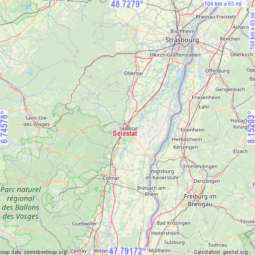
Sélestat GPS coordinates[2]
48° 15' 43.02" North, 7° 26' 56.04" East
| Map corner | latitude | longitude |
|---|---|---|
| Upper-left | 48.7279°, | 6.74578° |
| Center: | 48.26195°, | 7.4489° |
| Lower-right: | 47.79172°, | 8.15203° |
| Map W x H: | 104.1×104.1 km | = 64.7×64.7mi |
| max Lat: | 51.07786° ⇑36.2% North |
| Sélestat: | 48.26195° |
| min Lat: | ⇓63.8% South 41.3874° |
| min Long | Sélestat | max Long |
| -5.08615° | 7.4489° | 9.52242° |
| W 97.6%⇐ | ⇒2.4% E |
Elevation
Elevation of Sélestat is 172 m = 564 ft, and this is 21.7 m = 71 ft below average elevation for this country.
| Max E: |
2333 m = 7654 ft | 39.5% |
| Avg. | 193.7 m = 635 ft | |
| Sélestat | 172 m = 564 ft | |
Min E: |
-1 m = -3 ft | 60.5% |
See also: France elevation on elevation.city.
Geographical zone
Sélestat is located in North temperate zone (between Tropic of Cancer and the Arctic Circle). Distance of this North polar circle is 2034.9 km =1264.4 mi to North.| Distance of | km | miles | from Sélestat |
|---|---|---|---|
| North Pole | 4640.8 | 2883.7 | to North |
| Arctic Circle | 2034.9 | 1264.4 | to North |
| Tropic Cancer | 2760.3 | 1715.2 | to South |
| Equator | 5366.2 | 3334.4 | to South |


Nearby cities:
15 places around Sélestat: (largest is in red/bold)
• Baldenheim
7.2 km =4.5 mi,  111°
111°
• Bergheim
8.9 km =5.5 mi,  225°
225°
• Châtenois
3.7 km =2.3 mi,  287°
287°
• Dambach-la-Ville
7.1 km =4.4 mi,  345°
345°
• Ebersheim
6 km =3.7 mi,  38°
38°
• Ebersmunster
7.8 km =4.8 mi,  45°
45°
• Guémar
9 km =5.6 mi,  205°
205°
• Hilsenheim
8.9 km =5.5 mi,  71°
71°
• Illhaeusern
8.7 km =5.4 mi,  187°
187°
• Kintzheim
4.1 km =2.5 mi,  258°
258°
• Mussig
6.3 km =3.9 mi,  124°
124°
• Muttersholtz
6.5 km =4 mi,  84°
84°
• Orschwiller
5.3 km =3.3 mi,  244°
244°
• Saint-Hippolyte
6.7 km =4.2 mi, 239°
• Scherwiller
3.5 km =2.2 mi,  323°
323°
Sources, notices
• [Note1] Compared only with cities in France existing in our database
• [Src1] Map data: © OpenStreetMap contributors (CC-BY-SA)
• [Src2] Other city data from geonames.org with taken over terms of usage.
• [Src3] Geographical zone / Annual Mean Temperature by Robert A. Rohde @ Wikipedia
