Flavin geodata
Flavin (Occitanie) is a populated place; located in France in Europe/Paris (GMT+2) time zone. With population of 2,019 people, there are 4751 cities with bigger population in this country. Compared to other cities in France, 84.9% of cities are located further ↑North; 52.2% of cities are located further ←West and 96% of cities have lower elevation than Flavin. Note1
Administrative division(s):
- Level 1: Occitanie
- Level 2: Département de l'Aveyron
- Level 3: Arrondissement de Millau
- Level 4: Flavin


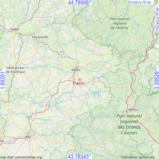
Flavin GPS coordinates[2]
44° 17' 20.04" North, 2° 36' 18.468" East
| Map corner | latitude | longitude |
|---|---|---|
| Upper-left | 44.79006°, | 1.90201° |
| Center: | 44.2889°, | 2.60513° |
| Lower-right: | 43.78343°, | 3.30826° |
| Map W x H: | 111.9×111.9 km | = 69.5×69.5mi |
| max Lat: | 51.07786° ⇑84.9% North |
| Flavin: | 44.2889° |
| min Lat: | ⇓15.1% South 41.3874° |
| min Long | Flavin | max Long |
| -5.08615° | 2.60513° | 9.52242° |
| W 52.2%⇐ | ⇒47.8% E |
Elevation
Elevation of Flavin is 648 m = 2126 ft, and this is 454.3 m = 1490 ft above average elevation for this country.
| Max E: |
2333 m = 7654 ft | 4% |
| Flavin | 648 m 2126 ft | |
| Avg. | 193.7 m = 635 ft | |
Min E: |
-1 m = -3 ft | 96% |
See also: France elevation on elevation.city.
Geographical zone
Flavin is located in North temperate zone (between Tropic of Cancer and the Arctic Circle). Distance of this Northern Tropic circle is 2318.5 km =1440.6 mi to South.| Distance of | km | miles | from Flavin |
|---|---|---|---|
| North Pole | 5082.6 | 3158.2 | to North |
| Arctic Circle | 2476.7 | 1538.9 | to North |
| Tropic Cancer | 2318.5 | 1440.6 | to South |
| Equator | 4924.5 | 3059.9 | to South |


Nearby cities:
15 places around Flavin: (largest is in red/bold)
• Arvieu
11.6 km =7.2 mi,  157°
157°
• Baraqueville
13.9 km =8.6 mi,  264°
264°
• Calmont
8.6 km =5.3 mi,  238°
238°
• Druelle
11.2 km =7 mi,  314°
314°
• La Loubière
10.5 km =6.5 mi,  28°
28°
• Le Monastère
6.2 km =3.9 mi,  340°
340°
• Luc-la-Primaube
6.2 km =3.9 mi,  297°
297°
• Manhac
11.5 km =7.1 mi,  250°
250°
• Olemps
7.7 km =4.8 mi,  326°
326°
• Pont-de-Salars
9.8 km =6.1 mi,  95°
95°
• Rodez
7.5 km =4.7 mi, 340°
• Sainte-Radegonde
5.7 km =3.5 mi,  17°
17°
• Salmiech
12.2 km =7.6 mi,  191°
191°
• Sébazac-Concourès
12.9 km =8 mi,  359°
359°
• Trémouilles
5.8 km =3.6 mi,  147°
147°
Sources, notices
• [Note1] Compared only with cities in France existing in our database
• [Src1] Map data: © OpenStreetMap contributors (CC-BY-SA)
• [Src2] Other city data from geonames.org with taken over terms of usage.
• [Src3] Geographical zone / Annual Mean Temperature by Robert A. Rohde @ Wikipedia
