Dolus-d'Oléron geodata
Dolus-d'Oléron (Nouvelle-Aquitaine) is a populated place; located in France in Europe/Paris (GMT+2) time zone. With population of 3,114 people, there are 3132 cities with bigger population in this country. Compared to other cities in France, 67.4% of cities are located further ↑North; 90.5% of cities are located further →East and 99.6% of cities have higher elevation than Dolus-d'Oléron. Note1
Administrative division(s):
- Level 1: Nouvelle-Aquitaine
- Level 2: Charente-Maritime
- Level 3: Arrondissement de Rochefort
- Level 4: Dolus-d'Oléron


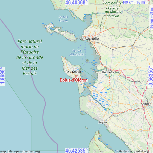
Dolus-d'Oléron GPS coordinates[2]
45° 55' 0.012" North, 1° 16' 0.012" West
| Map corner | latitude | longitude |
|---|---|---|
| Upper-left | 46.40368°, | -1.9698° |
| Center: | 45.91667°, | -1.26667° |
| Lower-right: | 45.42535°, | -0.56355° |
| Map W x H: | 108.8×108.8 km | = 67.6×67.6mi |
| max Lat: | 51.07786° ⇑67.4% North |
| Dolus-d'Oléron: | 45.91667° |
| min Lat: | ⇓32.6% South 41.3874° |
| min Long | Dolus-d'Oléron | max Long |
| -5.08615° | -1.26667° | 9.52242° |
| W 9.5%⇐ | ⇒90.5% E |
Elevation
Elevation of Dolus-d'Oléron is 4 m = 13 ft, and this is 189.7 m = 622 ft below average elevation for this country.
| Max E: |
2333 m = 7654 ft | 99.6% |
| Avg. | 193.7 m = 635 ft | |
| Dolus-d'Oléron | 4 m = 13 ft | |
Min E: |
-1 m = -3 ft | 0.4% |
See also: France elevation on elevation.city.
Geographical zone
Dolus-d'Oléron is located in North temperate zone (between Tropic of Cancer and the Arctic Circle). Distance of this North polar circle is 2295.7 km =1426.5 mi to North.| Distance of | km | miles | from Dolus-d'Oléron |
|---|---|---|---|
| North Pole | 4901.6 | 3045.7 | to North |
| Arctic Circle | 2295.7 | 1426.5 | to North |
| Tropic Cancer | 2499.5 | 1553.1 | to South |
| Equator | 5105.5 | 3172.4 | to South |


Nearby cities:
15 places around Dolus-d'Oléron: (largest is in red/bold)
• Bourcefranc-le-Chapus
11.7 km =7.3 mi,  129°
129°
• Boyard-Ville
5.9 km =3.7 mi,  18°
18°
• Fouras
15.6 km =9.7 mi,  59°
59°
• Hiers-Brouage
16.8 km =10.4 mi,  116°
116°
• La Brée-les-Bains
12.7 km =7.9 mi,  329°
329°
• La Tremblade
19.1 km =11.9 mi,  149°
149°
• Le Grand-Village-Plage
6.1 km =3.8 mi,  155°
155°
• Marennes
16.3 km =10.1 mi, 129°
• Moëze
18 km =11.2 mi,  94°
94°
• Port-des-Barques
15 km =9.3 mi,  76°
76°
• Saint-Denis-d’Oléron
15.7 km =9.8 mi, 326°
• Saint-Laurent-de-la-Prée
19.3 km =12 mi,  67°
67°
• Saint-Nazaire-sur-Charente
16.7 km =10.4 mi, 82°
• Saint-Pierre-d’Oléron
4.3 km =2.7 mi,  315°
315°
• Saint-Trojan-les-Bains
9.6 km =6 mi, 151°
Sources, notices
• [Note1] Compared only with cities in France existing in our database
• [Src1] Map data: © OpenStreetMap contributors (CC-BY-SA)
• [Src2] Other city data from geonames.org with taken over terms of usage.
• [Src3] Geographical zone / Annual Mean Temperature by Robert A. Rohde @ Wikipedia
