Bourcefranc-le-Chapus geodata
Bourcefranc-le-Chapus (Nouvelle-Aquitaine) is a populated place; located in France in Europe/Paris (GMT+2) time zone. With population of 3,275 people, there are 2975 cities with bigger population in this country. Compared to other cities in France, 68.5% of cities are located further ↑North; 89.6% of cities are located further →East and 99.6% of cities have higher elevation than Bourcefranc-le-Chapus. Note1
Administrative division(s):
- Level 1: Nouvelle-Aquitaine
- Level 2: Charente-Maritime
- Level 3: Arrondissement de Rochefort
- Level 4: Bourcefranc-le-Chapus
Current local time in Bourcefranc-le-Chapus:
08:36 AM, SaturdayDifference from your time zone: hours


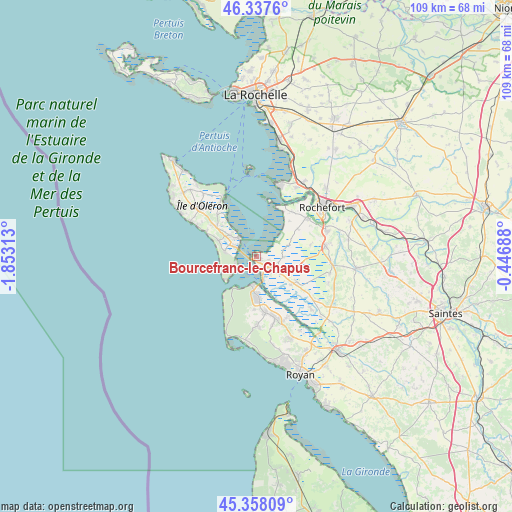
Bourcefranc-le-Chapus GPS coordinates[2]
45° 51' 0" North, 1° 9' 0" West
| Map corner | latitude | longitude |
|---|---|---|
| Upper-left | 46.3376°, | -1.85313° |
| Center: | 45.85°, | -1.15° |
| Lower-right: | 45.35809°, | -0.44688° |
| Map W x H: | 108.9×108.9 km | = 67.7×67.7mi |
| max Lat: | 51.07786° ⇑68.5% North |
| Bourcefranc-le-Chapus: | 45.85° |
| min Lat: | ⇓31.5% South 41.3874° |
| min Long | Bourcefranc-le- | max Long |
| -5.08615° | -1.15° | 9.52242° |
| W 10.4%⇐ | ⇒89.6% E |
Elevation
Elevation of Bourcefranc-le-Chapus is 4 m = 13 ft, and this is 189.7 m = 622 ft below average elevation for this country.
| Max E: |
2333 m = 7654 ft | 99.6% |
| Avg. | 193.7 m = 635 ft | |
| Bourcefranc-le-Chapus | 4 m = 13 ft | |
Min E: |
-1 m = -3 ft | 0.4% |
See also: France elevation on elevation.city.
Geographical zone
Bourcefranc-le-Chapus is located in North temperate zone (between Tropic of Cancer and the Arctic Circle). Distance of this North polar circle is 2303.1 km =1431.1 mi to North.| Distance of | km | miles | from Bourcefranc-le-Chapus |
|---|---|---|---|
| North Pole | 4909 | 3050.3 | to North |
| Arctic Circle | 2303.1 | 1431.1 | to North |
| Tropic Cancer | 2492.1 | 1548.5 | to South |
| Equator | 5098 | 3167.7 | to South |


Nearby cities:
15 places around Bourcefranc-le-Chapus: (largest is in red/bold)
• Arvert
11.8 km =7.3 mi,  170°
170°
• Boyard-Ville
14.9 km =9.3 mi,  331°
331°
• Dolus-d'Oléron
11.7 km =7.3 mi,  309°
309°
• Hiers-Brouage
6 km =3.7 mi,  91°
91°
• La Tremblade
9.1 km =5.7 mi,  176°
176°
• Le Grand-Village-Plage
6.7 km =4.2 mi,  286°
286°
• Marennes
4.6 km =2.9 mi,  131°
131°
• Moëze
10.7 km =6.6 mi,  55°
55°
• Port-des-Barques
12.2 km =7.6 mi,  27°
27°
• Saint-Agnant
14.9 km =9.3 mi,  79°
79°
• Saint-Just-Luzac
10.6 km =6.6 mi,  121°
121°
• Saint-Nazaire-sur-Charente
12.2 km =7.6 mi,  38°
38°
• Saint-Trojan-les-Bains
4.5 km =2.8 mi,  257°
257°
• Soubise
13.6 km =8.5 mi,  52°
52°
• Étaules
13.5 km =8.4 mi,  163°
163°
Sources, notices
• [Note1] Compared only with cities in France existing in our database
• [Src1] Map data: © OpenStreetMap contributors (CC-BY-SA)
• [Src2] Other city data from geonames.org with taken over terms of usage.
• [Src3] Geographical zone / Annual Mean Temperature by Robert A. Rohde @ Wikipedia
