Dambenois geodata
Dambenois (Bourgogne-Franche-Comté) is a populated place; located in France in Europe/Paris (GMT+2) time zone. With population of 660 people, there are 12381 cities with bigger population in this country. Compared to other cities in France, 51.9% of cities are located further ↓South; 94.1% of cities are located further ←West and 84% of cities have lower elevation than Dambenois. Note1
Administrative division(s):
- Level 1: Bourgogne-Franche-Comté
- Level 2: Doubs
- Level 3: Arrondissement de Montbéliard
- Level 4: Dambenois


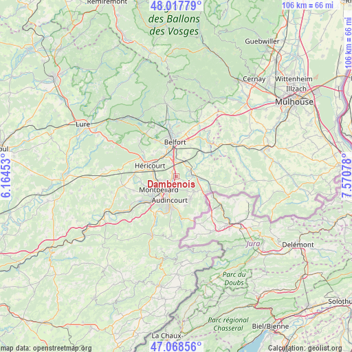
Dambenois GPS coordinates[2]
47° 32' 43.152" North, 6° 52' 3.54" East
| Map corner | latitude | longitude |
|---|---|---|
| Upper-left | 48.01779°, | 6.16453° |
| Center: | 47.54532°, | 6.86765° |
| Lower-right: | 47.06856°, | 7.57078° |
| Map W x H: | 105.5×105.5 km | = 65.6×65.6mi |
| max Lat: | 51.07786° ⇑48.1% North |
| Dambenois: | 47.54532° |
| min Lat: | ⇓51.9% South 41.3874° |
| min Long | Dambenois | max Long |
| -5.08615° | 6.86765° | 9.52242° |
| W 94.1%⇐ | ⇒5.9% E |
Elevation
Elevation of Dambenois is 335 m = 1099 ft, and this is 141.3 m = 464 ft above average elevation for this country.
| Max E: |
2333 m = 7654 ft | 16% |
| Dambenois | 335 m 1099 ft | |
| Avg. | 193.7 m = 635 ft | |
Min E: |
-1 m = -3 ft | 84% |
See also: France elevation on elevation.city.
Geographical zone
Dambenois is located in North temperate zone (between Tropic of Cancer and the Arctic Circle). Distance of this North polar circle is 2114.6 km =1314 mi to North.| Distance of | km | miles | from Dambenois |
|---|---|---|---|
| North Pole | 4720.5 | 2933.2 | to North |
| Arctic Circle | 2114.6 | 1314 | to North |
| Tropic Cancer | 2680.6 | 1665.6 | to South |
| Equator | 5286.5 | 3284.9 | to South |


Nearby cities:
15 places around Dambenois: (largest is in red/bold)
• Allenjoie
2.5 km =1.6 mi,  117°
117°
• Bethoncourt
4.8 km =3 mi,  256°
256°
• Bourogne
4.2 km =2.6 mi,  61°
61°
• Châtenois-les-Forges
2.1 km =1.3 mi,  316°
316°
• Dampierre-les-Bois
5.5 km =3.4 mi,  141°
141°
• Dorans
5.3 km =3.3 mi,  335°
335°
• Fesches-le-Châtel
3.7 km =2.3 mi,  129°
129°
• Grand-Charmont
3.7 km =2.3 mi,  236°
236°
• Morvillars
5 km =3.1 mi,  85°
85°
• Méziré
4.2 km =2.6 mi,  108°
108°
• Nommay
2.1 km =1.3 mi,  246°
246°
• Sevenans
4.6 km =2.9 mi,  358°
358°
• Sochaux
5.1 km =3.2 mi,  216°
216°
• Vieux-Charmont
3.5 km =2.2 mi, 221°
• Étupes
4.5 km =2.8 mi,  177°
177°
Sources, notices
• [Note1] Compared only with cities in France existing in our database
• [Src1] Map data: © OpenStreetMap contributors (CC-BY-SA)
• [Src2] Other city data from geonames.org with taken over terms of usage.
• [Src3] Geographical zone / Annual Mean Temperature by Robert A. Rohde @ Wikipedia
