Bethoncourt geodata
Bethoncourt (Bourgogne-Franche-Comté) is a populated place; located in France in Europe/Paris (GMT+2) time zone. With population of 7,182 people, there are 1355 cities with bigger population in this country. Compared to other cities in France, 51.8% of cities are located further ↓South; 93.7% of cities are located further ←West and 86.1% of cities have lower elevation than Bethoncourt. Note1
Administrative division(s):
- Level 1: Bourgogne-Franche-Comté
- Level 2: Doubs
- Level 3: Arrondissement de Montbéliard
- Level 4: Bethoncourt


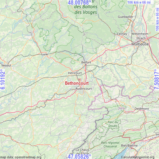
Bethoncourt GPS coordinates[2]
47° 32' 6.432" North, 6° 48' 18.144" East
| Map corner | latitude | longitude |
|---|---|---|
| Upper-left | 48.00768°, | 6.10192° |
| Center: | 47.53512°, | 6.80504° |
| Lower-right: | 47.05826°, | 7.50817° |
| Map W x H: | 105.6×105.6 km | = 65.6×65.6mi |
| max Lat: | 51.07786° ⇑48.2% North |
| Bethoncourt: | 47.53512° |
| min Lat: | ⇓51.8% South 41.3874° |
| min Long | Bethoncourt | max Long |
| -5.08615° | 6.80504° | 9.52242° |
| W 93.7%⇐ | ⇒6.3% E |
Elevation
Elevation of Bethoncourt is 361 m = 1184 ft, and this is 167.3 m = 549 ft above average elevation for this country.
| Max E: |
2333 m = 7654 ft | 13.9% |
| Bethoncourt | 361 m 1184 ft | |
| Avg. | 193.7 m = 635 ft | |
Min E: |
-1 m = -3 ft | 86.1% |
See also: France elevation on elevation.city.
Geographical zone
Bethoncourt is located in North temperate zone (between Tropic of Cancer and the Arctic Circle). Distance of this North polar circle is 2115.8 km =1314.7 mi to North.| Distance of | km | miles | from Bethoncourt |
|---|---|---|---|
| North Pole | 4721.7 | 2933.9 | to North |
| Arctic Circle | 2115.8 | 1314.7 | to North |
| Tropic Cancer | 2679.5 | 1665 | to South |
| Equator | 5285.4 | 3284.2 | to South |


Nearby cities:
15 places around Bethoncourt: (largest is in red/bold)
• Arbouans
4 km =2.5 mi,  190°
190°
• Brevilliers
5.4 km =3.4 mi,  347°
347°
• Châtenois-les-Forges
4.2 km =2.6 mi,  51°
51°
• Courcelles-lès-Montbéliard
4.1 km =2.5 mi,  202°
202°
• Dambenois
4.8 km =3 mi,  76°
76°
• Dung
5.3 km =3.3 mi,  227°
227°
• Exincourt
4.9 km =3 mi,  156°
156°
• Grand-Charmont
1.8 km =1.1 mi,  120°
120°
• Héricourt
5.3 km =3.3 mi,  322°
322°
• Montbéliard
2.9 km =1.8 mi, 190°
• Nommay
2.8 km =1.7 mi, 83°
• Sainte-Suzanne
4.8 km =3 mi,  215°
215°
• Sochaux
3.4 km =2.1 mi,  150°
150°
• Taillecourt
5.8 km =3.6 mi,  140°
140°
• Vieux-Charmont
2.8 km =1.7 mi, 121°
Sources, notices
• [Note1] Compared only with cities in France existing in our database
• [Src1] Map data: © OpenStreetMap contributors (CC-BY-SA)
• [Src2] Other city data from geonames.org with taken over terms of usage.
• [Src3] Geographical zone / Annual Mean Temperature by Robert A. Rohde @ Wikipedia
