Sochaux geodata
Sochaux (Bourgogne-Franche-Comté) is a populated place; located in France in Europe/Paris (GMT+2) time zone. With population of 4,500 people, there are 2195 cities with bigger population in this country. Compared to other cities in France, 51.3% of cities are located further ↓South; 93.8% of cities are located further ←West and 83.2% of cities have lower elevation than Sochaux. Note1
Administrative division(s):
- Level 1: Bourgogne-Franche-Comté
- Level 2: Doubs
- Level 3: Arrondissement de Montbéliard
- Level 4: Sochaux


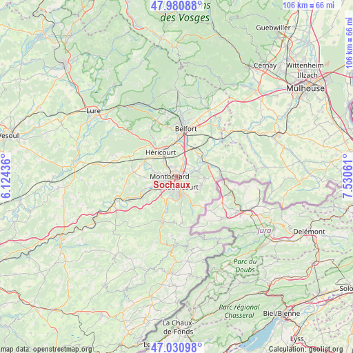
Sochaux GPS coordinates[2]
47° 30' 29.088" North, 6° 49' 38.928" East
| Map corner | latitude | longitude |
|---|---|---|
| Upper-left | 47.98088°, | 6.12436° |
| Center: | 47.50808°, | 6.82748° |
| Lower-right: | 47.03098°, | 7.53061° |
| Map W x H: | 105.6×105.6 km | = 65.6×65.6mi |
| max Lat: | 51.07786° ⇑48.7% North |
| Sochaux: | 47.50808° |
| min Lat: | ⇓51.3% South 41.3874° |
| min Long | Sochaux | max Long |
| -5.08615° | 6.82748° | 9.52242° |
| W 93.8%⇐ | ⇒6.2% E |
Elevation
Elevation of Sochaux is 324 m = 1063 ft, and this is 130.3 m = 427 ft above average elevation for this country.
| Max E: |
2333 m = 7654 ft | 16.8% |
| Sochaux | 324 m 1063 ft | |
| Avg. | 193.7 m = 635 ft | |
Min E: |
-1 m = -3 ft | 83.2% |
See also: France elevation on elevation.city.
Geographical zone
Sochaux is located in North temperate zone (between Tropic of Cancer and the Arctic Circle). Distance of this North polar circle is 2118.8 km =1316.6 mi to North.| Distance of | km | miles | from Sochaux |
|---|---|---|---|
| North Pole | 4724.7 | 2935.8 | to North |
| Arctic Circle | 2118.8 | 1316.6 | to North |
| Tropic Cancer | 2676.5 | 1663.1 | to South |
| Equator | 5282.4 | 3282.3 | to South |


Nearby cities:
15 places around Sochaux: (largest is in red/bold)
• Arbouans
2.6 km =1.6 mi,  248°
248°
• Audincourt
3.4 km =2.1 mi,  144°
144°
• Bart
4.8 km =3 mi,  243°
243°
• Bethoncourt
3.4 km =2.1 mi,  330°
330°
• Courcelles-lès-Montbéliard
3.3 km =2.1 mi,  256°
256°
• Dambenois
5.1 km =3.2 mi,  36°
36°
• Exincourt
1.5 km =0.9 mi,  168°
168°
• Grand-Charmont
2.1 km =1.3 mi,  357°
357°
• Montbéliard
2.2 km =1.4 mi,  274°
274°
• Nommay
3.5 km =2.2 mi,  18°
18°
• Sainte-Suzanne
4.6 km =2.9 mi, 258°
• Taillecourt
2.5 km =1.6 mi,  125°
125°
• Valentigney
4.9 km =3 mi,  176°
176°
• Vieux-Charmont
1.7 km =1.1 mi,  25°
25°
• Étupes
3.3 km =2.1 mi,  95°
95°
Sources, notices
• [Note1] Compared only with cities in France existing in our database
• [Src1] Map data: © OpenStreetMap contributors (CC-BY-SA)
• [Src2] Other city data from geonames.org with taken over terms of usage.
• [Src3] Geographical zone / Annual Mean Temperature by Robert A. Rohde @ Wikipedia
