Augerolles geodata
Augerolles (Auvergne-Rhône-Alpes) is a populated place; located in France in Europe/Paris (GMT+2) time zone. With population of 931 people, there are 9375 cities with bigger population in this country. Compared to other cities in France, 70.5% of cities are located further ↑North; 65.2% of cities are located further ←West and 94% of cities have lower elevation than Augerolles. Note1
Administrative division(s):
- Level 1: Auvergne-Rhône-Alpes
- Level 2: Département du Puy-de-Dôme
- Level 3: Arrondissement de Thiers
- Level 4: Augerolles


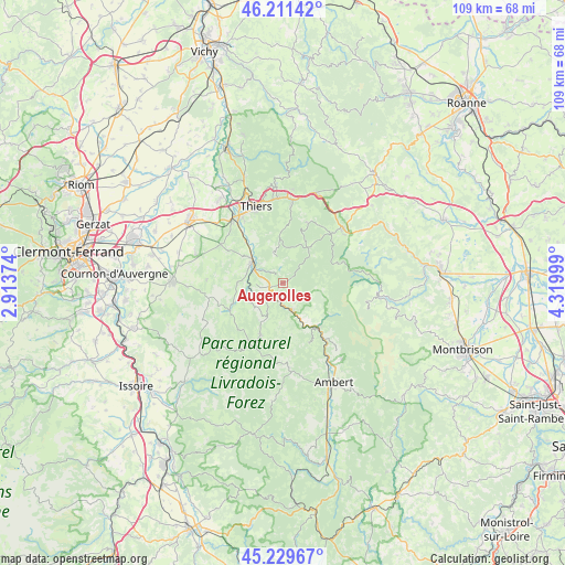
Augerolles GPS coordinates[2]
45° 43' 21.72" North, 3° 37' 0.696" East
| Map corner | latitude | longitude |
|---|---|---|
| Upper-left | 46.21142°, | 2.91374° |
| Center: | 45.7227°, | 3.61686° |
| Lower-right: | 45.22967°, | 4.31999° |
| Map W x H: | 109.2×109.2 km | = 67.9×67.9mi |
| max Lat: | 51.07786° ⇑70.5% North |
| Augerolles: | 45.7227° |
| min Lat: | ⇓29.5% South 41.3874° |
| min Long | Augerolles | max Long |
| -5.08615° | 3.61686° | 9.52242° |
| W 65.2%⇐ | ⇒34.8% E |
Elevation
Elevation of Augerolles is 542 m = 1778 ft, and this is 348.3 m = 1143 ft above average elevation for this country.
| Max E: |
2333 m = 7654 ft | 6% |
| Augerolles | 542 m 1778 ft | |
| Avg. | 193.7 m = 635 ft | |
Min E: |
-1 m = -3 ft | 94% |
See also: France elevation on elevation.city.
Geographical zone
Augerolles is located in North temperate zone (between Tropic of Cancer and the Arctic Circle). Distance of this North polar circle is 2317.3 km =1439.9 mi to North.| Distance of | km | miles | from Augerolles |
|---|---|---|---|
| North Pole | 4923.2 | 3059.1 | to North |
| Arctic Circle | 2317.3 | 1439.9 | to North |
| Tropic Cancer | 2478 | 1539.8 | to South |
| Equator | 5083.9 | 3159 | to South |


Nearby cities:
15 places around Augerolles: (largest is in red/bold)
• Bertignat
12.7 km =7.9 mi,  157°
157°
• Celles-sur-Durolle
15.1 km =9.4 mi,  5°
5°
• Courpière
6.9 km =4.3 mi,  303°
303°
• Cunlhat
11 km =6.8 mi,  203°
203°
• Escoutoux
11.5 km =7.1 mi,  338°
338°
• Job
15.5 km =9.6 mi,  139°
139°
• Marat
8.7 km =5.4 mi, 144°
• Noirétable
15.4 km =9.6 mi,  47°
47°
• Olliergues
5.5 km =3.4 mi, 163°
• Peschadoires
15 km =9.3 mi,  320°
320°
• Saint-Dier-d’Auvergne
11.7 km =7.3 mi,  243°
243°
• Sermentizon
10 km =6.2 mi, 295°
• Tours-sur-Meymont
6.5 km =4 mi,  209°
209°
• Vertolaye
10.7 km =6.6 mi, 139°
• Vollore-Ville
7 km =4.3 mi,  349°
349°
Sources, notices
• [Note1] Compared only with cities in France existing in our database
• [Src1] Map data: © OpenStreetMap contributors (CC-BY-SA)
• [Src2] Other city data from geonames.org with taken over terms of usage.
• [Src3] Geographical zone / Annual Mean Temperature by Robert A. Rohde @ Wikipedia
