Culmont geodata
Culmont (Grand Est) is a populated place; located in France in Europe/Paris (GMT+2) time zone. With population of 580 people, there are 13652 cities with bigger population in this country. Compared to other cities in France, 56.2% of cities are located further ↓South; 82.4% of cities are located further ←West and 82.6% of cities have lower elevation than Culmont. Note1
Administrative division(s):
- Level 1: Grand Est
- Level 2: Haute-Marne
- Level 3: Arrondissement de Langres
- Level 4: Culmont


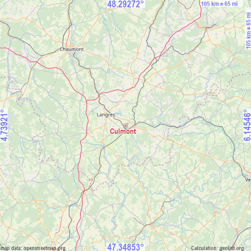
Culmont GPS coordinates[2]
47° 49' 21.972" North, 5° 26' 32.388" East
| Map corner | latitude | longitude |
|---|---|---|
| Upper-left | 48.29272°, | 4.73921° |
| Center: | 47.82277°, | 5.44233° |
| Lower-right: | 47.34853°, | 6.14546° |
| Map W x H: | 105×105 km | = 65.2×65.2mi |
| max Lat: | 51.07786° ⇑43.8% North |
| Culmont: | 47.82277° |
| min Lat: | ⇓56.2% South 41.3874° |
| min Long | Culmont | max Long |
| -5.08615° | 5.44233° | 9.52242° |
| W 82.4%⇐ | ⇒17.6% E |
Elevation
Elevation of Culmont is 317 m = 1040 ft, and this is 123.3 m = 405 ft above average elevation for this country.
| Max E: |
2333 m = 7654 ft | 17.4% |
| Culmont | 317 m 1040 ft | |
| Avg. | 193.7 m = 635 ft | |
Min E: |
-1 m = -3 ft | 82.6% |
See also: France elevation on elevation.city.
Geographical zone
Culmont is located in North temperate zone (between Tropic of Cancer and the Arctic Circle). Distance of this North polar circle is 2083.8 km =1294.8 mi to North.| Distance of | km | miles | from Culmont |
|---|---|---|---|
| North Pole | 4689.7 | 2914 | to North |
| Arctic Circle | 2083.8 | 1294.8 | to North |
| Tropic Cancer | 2711.5 | 1684.8 | to South |
| Equator | 5317.4 | 3304.1 | to South |


Nearby cities:
15 places around Culmont: (largest is in red/bold)
• Avrecourt
17.1 km =10.6 mi,  24°
24°
• Chalindrey
2.4 km =1.5 mi,  206°
206°
• Chézeaux
16.5 km =10.3 mi,  68°
68°
• Fayl-Billot
12.6 km =7.8 mi,  111°
111°
• Haute-Amance
8.1 km =5 mi,  81°
81°
• Humes-Jorquenay
14.6 km =9.1 mi,  305°
305°
• Langres
9.3 km =5.8 mi,  298°
298°
• Longeau-Percey
12.3 km =7.6 mi,  239°
239°
• Prauthoy
19.4 km =12.1 mi, 214°
• Rolampont
18.3 km =11.4 mi,  320°
320°
• Saints-Geosmes
8.2 km =5.1 mi,  278°
278°
• Saulxures
18.2 km =11.3 mi,  35°
35°
• Torcenay
2 km =1.2 mi,  116°
116°
• Val-de-Meuse
20.2 km =12.6 mi,  12°
12°
• Villegusien-le-Lac
13.2 km =8.2 mi,  223°
223°
Sources, notices
• [Note1] Compared only with cities in France existing in our database
• [Src1] Map data: © OpenStreetMap contributors (CC-BY-SA)
• [Src2] Other city data from geonames.org with taken over terms of usage.
• [Src3] Geographical zone / Annual Mean Temperature by Robert A. Rohde @ Wikipedia
