Arinthod geodata
Arinthod (Bourgogne-Franche-Comté) is a populated place; located in France in Europe/Paris (GMT+2) time zone. With population of 1,273 people, there are 7156 cities with bigger population in this country. Compared to other cities in France, 61.2% of cities are located further ↑North; 83.5% of cities are located further ←West and 91.1% of cities have lower elevation than Arinthod. Note1
Administrative division(s):
- Level 1: Bourgogne-Franche-Comté
- Level 2: Jura
- Level 3: Arrondissement de Lons-le-Saunier
- Level 4: Arinthod


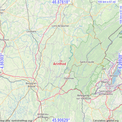
Arinthod GPS coordinates[2]
46° 23' 36.204" North, 5° 33' 58.176" East
| Map corner | latitude | longitude |
|---|---|---|
| Upper-left | 46.87618°, | 4.86303° |
| Center: | 46.39339°, | 5.56616° |
| Lower-right: | 45.90629°, | 6.26928° |
| Map W x H: | 107.8×107.8 km | = 67×67mi |
| max Lat: | 51.07786° ⇑61.2% North |
| Arinthod: | 46.39339° |
| min Lat: | ⇓38.8% South 41.3874° |
| min Long | Arinthod | max Long |
| -5.08615° | 5.56616° | 9.52242° |
| W 83.5%⇐ | ⇒16.5% E |
Elevation
Elevation of Arinthod is 452 m = 1483 ft, and this is 258.3 m = 847 ft above average elevation for this country.
| Max E: |
2333 m = 7654 ft | 8.9% |
| Arinthod | 452 m 1483 ft | |
| Avg. | 193.7 m = 635 ft | |
Min E: |
-1 m = -3 ft | 91.1% |
See also: France elevation on elevation.city.
Geographical zone
Arinthod is located in North temperate zone (between Tropic of Cancer and the Arctic Circle). Distance of this North polar circle is 2242.7 km =1393.5 mi to North.| Distance of | km | miles | from Arinthod |
|---|---|---|---|
| North Pole | 4848.6 | 3012.8 | to North |
| Arctic Circle | 2242.7 | 1393.5 | to North |
| Tropic Cancer | 2552.5 | 1586 | to South |
| Equator | 5158.5 | 3205.3 | to South |


Nearby cities:
15 places around Arinthod: (largest is in red/bold)
• Arbent
14.2 km =8.8 mi,  142°
142°
• Aromas
12.9 km =8 mi,  210°
210°
• Chassal
17.2 km =10.7 mi,  103°
103°
• Coligny
17 km =10.6 mi,  265°
265°
• Dortan
10.9 km =6.8 mi, 138°
• Géovreisset
15.7 km =9.8 mi,  165°
165°
• Lavans-lès-Saint-Claude
16.6 km =10.3 mi,  93°
93°
• Moirans-en-Montagne
13.1 km =8.1 mi,  69°
69°
• Molinges
15.8 km =9.8 mi,  105°
105°
• Orgelet
14.6 km =9.1 mi,  13°
13°
• Oyonnax
16.5 km =10.3 mi,  154°
154°
• Pratz
15.1 km =9.4 mi, 96°
• Thoirette
14 km =8.7 mi,  191°
191°
• Vaux-lès-Saint-Claude
13.7 km =8.5 mi, 106°
• Viry
16.8 km =10.4 mi,  128°
128°
Sources, notices
• [Note1] Compared only with cities in France existing in our database
• [Src1] Map data: © OpenStreetMap contributors (CC-BY-SA)
• [Src2] Other city data from geonames.org with taken over terms of usage.
• [Src3] Geographical zone / Annual Mean Temperature by Robert A. Rohde @ Wikipedia
