Bracieux geodata
Bracieux (Centre) is a populated place; located in France in Europe/Paris (GMT+2) time zone. With population of 1,203 people, there are 7511 cities with bigger population in this country. Compared to other cities in France, 52% of cities are located further ↓South; 62.5% of cities are located further →East and 69.2% of cities have higher elevation than Bracieux. Note1
Administrative division(s):
- Level 1: Centre
- Level 2: Département du Loir-et-Cher
- Level 3: Arrondissement de Blois
- Level 4: Bracieux


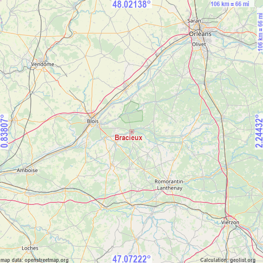
Bracieux GPS coordinates[2]
47° 32' 56.22" North, 1° 32' 28.32" East
| Map corner | latitude | longitude |
|---|---|---|
| Upper-left | 48.02138°, | 0.83807° |
| Center: | 47.54895°, | 1.5412° |
| Lower-right: | 47.07222°, | 2.24432° |
| Map W x H: | 105.5×105.5 km | = 65.6×65.6mi |
| max Lat: | 51.07786° ⇑48% North |
| Bracieux: | 47.54895° |
| min Lat: | ⇓52% South 41.3874° |
| min Long | Bracieux | max Long |
| -5.08615° | 1.5412° | 9.52242° |
| W 37.5%⇐ | ⇒62.5% E |
Elevation
Elevation of Bracieux is 80 m = 262 ft, and this is 113.7 m = 373 ft below average elevation for this country.
| Max E: |
2333 m = 7654 ft | 69.2% |
| Avg. | 193.7 m = 635 ft | |
| Bracieux | 80 m = 262 ft | |
Min E: |
-1 m = -3 ft | 30.8% |
See also: France elevation on elevation.city.
Geographical zone
Bracieux is located in North temperate zone (between Tropic of Cancer and the Arctic Circle). Distance of this North polar circle is 2114.2 km =1313.7 mi to North.| Distance of | km | miles | from Bracieux |
|---|---|---|---|
| North Pole | 4720.1 | 2932.9 | to North |
| Arctic Circle | 2114.2 | 1313.7 | to North |
| Tropic Cancer | 2681 | 1665.9 | to South |
| Equator | 5286.9 | 3285.1 | to South |


Nearby cities:
15 places around Bracieux: (largest is in red/bold)
• Cellettes
12.3 km =7.6 mi,  258°
258°
• Cheverny
8.1 km =5 mi,  228°
228°
• Cormeray
12 km =7.5 mi,  238°
238°
• Cour-Cheverny
7.7 km =4.8 mi, 236°
• Crouy-sur-Cosson
12.4 km =7.7 mi,  24°
24°
• Dhuizon
9.7 km =6 mi,  64°
64°
• Fontaines-en-Sologne
4.5 km =2.8 mi,  171°
171°
• Huisseau-sur-Cosson
8.2 km =5.1 mi,  306°
306°
• Maslives
10.5 km =6.5 mi,  333°
333°
• Mont-près-Chambord
6.5 km =4 mi,  283°
283°
• Montlivault
12.4 km =7.7 mi,  324°
324°
• Saint-Claude-de-Diray
11.9 km =7.4 mi, 309°
• Saint-Dyé-sur-Loire
12.5 km =7.8 mi,  341°
341°
• Tour-en-Sologne
2.9 km =1.8 mi,  249°
249°
• Vernou-en-Sologne
11.7 km =7.3 mi,  117°
117°
Sources, notices
• [Note1] Compared only with cities in France existing in our database
• [Src1] Map data: © OpenStreetMap contributors (CC-BY-SA)
• [Src2] Other city data from geonames.org with taken over terms of usage.
• [Src3] Geographical zone / Annual Mean Temperature by Robert A. Rohde @ Wikipedia
