Crisenoy geodata
Crisenoy (Île-de-France) is a populated place; located in France in Europe/Paris (GMT+2) time zone. With population of 639 people, there are 12686 cities with bigger population in this country. Compared to other cities in France, 70.7% of cities are located further ↓South; 54.1% of cities are located further ←West and 64.4% of cities have higher elevation than Crisenoy. Note1
Administrative division(s):
- Level 1: Île-de-France
- Level 2: Seine-et-Marne
- Level 3: Arrondissement de Melun
- Level 4: Crisenoy


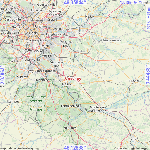
Crisenoy GPS coordinates[2]
48° 35' 43.98" North, 2° 44' 30.336" East
| Map corner | latitude | longitude |
|---|---|---|
| Upper-left | 49.05844°, | 2.03863° |
| Center: | 48.59555°, | 2.74176° |
| Lower-right: | 48.12838°, | 3.44488° |
| Map W x H: | 103.4×103.4 km | = 64.2×64.2mi |
| max Lat: | 51.07786° ⇑29.3% North |
| Crisenoy: | 48.59555° |
| min Lat: | ⇓70.7% South 41.3874° |
| min Long | Crisenoy | max Long |
| -5.08615° | 2.74176° | 9.52242° |
| W 54.1%⇐ | ⇒45.9% E |
Elevation
Elevation of Crisenoy is 91 m = 299 ft, and this is 102.7 m = 337 ft below average elevation for this country.
| Max E: |
2333 m = 7654 ft | 64.4% |
| Avg. | 193.7 m = 635 ft | |
| Crisenoy | 91 m = 299 ft | |
Min E: |
-1 m = -3 ft | 35.6% |
See also: France elevation on elevation.city.
Geographical zone
Crisenoy is located in North temperate zone (between Tropic of Cancer and the Arctic Circle). Distance of this North polar circle is 1997.9 km =1241.4 mi to North.| Distance of | km | miles | from Crisenoy |
|---|---|---|---|
| North Pole | 4603.7 | 2860.6 | to North |
| Arctic Circle | 1997.9 | 1241.4 | to North |
| Tropic Cancer | 2797.4 | 1738.2 | to South |
| Equator | 5403.3 | 3357.5 | to South |


Nearby cities:
15 places around Crisenoy: (largest is in red/bold)
• Blandy
4.3 km =2.7 mi,  136°
136°
• Champdeuil
3 km =1.9 mi,  340°
340°
• Champeaux
4.9 km =3 mi,  104°
104°
• Fouju
2.9 km =1.8 mi,  112°
112°
• Guignes
6 km =3.7 mi,  45°
45°
• Maincy
5.9 km =3.7 mi,  211°
211°
• Moisenay
3.7 km =2.3 mi,  187°
187°
• Montereau-sur-le-Jard
5.4 km =3.4 mi,  265°
265°
• Rubelles
6.7 km =4.2 mi,  225°
225°
• Saint-Germain-Laxis
2.8 km =1.7 mi,  236°
236°
• Sivry-Courtry
7.5 km =4.7 mi,  172°
172°
• Soignolles-en-Brie
7.1 km =4.4 mi,  334°
334°
• Solers
7.3 km =4.5 mi,  345°
345°
• Voisenon
6.3 km =3.9 mi, 244°
• Yèbles
4.9 km =3 mi,  23°
23°
Sources, notices
• [Note1] Compared only with cities in France existing in our database
• [Src1] Map data: © OpenStreetMap contributors (CC-BY-SA)
• [Src2] Other city data from geonames.org with taken over terms of usage.
• [Src3] Geographical zone / Annual Mean Temperature by Robert A. Rohde @ Wikipedia
